Average weekend, great swell Monday

South Australian Forecast by Craig Brokensha (issued Friday 23rd December)
It's only two sleeps to go until Christmas Day. If you're looking for a surfer's perfect present and don't want to endure the shopping centre masses you can pick up a Swellnet Pro Subscription gift pack. Treat someone else or treat yourself and get a free Swellnet leggy and surf tested sunscreen: https://www.swellnet.com/pro/gift
Best Days: Mid Coast tiny peelers over the weekend, Sunday morning swell magnets South Coast, both coasts Monday (morning South Coast), both coasts Tuesday morning, South Coast Wednesday
Recap
Pumping Mid Coast waves to a consistent 2-3ft Wednesday afternoon, easing back yesterday to 1-1.5ft with better 2ft sets on the favourable parts of the tide. Today we're back to tiny 1ft sets with glassy conditions ahead of a hot one.
The South Coast improved yesterday morning with a lighter E'ly breeze, but today is the pick with clean 2-3ft surf off Middleton and good waves out at Waits and Parsons.
This weekend and next week (Dec 24 – 30)
There's been no real change to the weekend's forecast with tiny 1ft sets due to linger on the Mid Coast, while the South Coast will become small.
Middleton looks to come in around an infrequent 1-1.5ft with 2-3ft sets at Waits and Parsons.
Winds are looking a little dicey tomorrow with a dawn variable breeze down South likely to come up from the S'th shortly thereafter ahead of S/SE sea breezes. The Mid Coast should be clean with a light S'ly wind ahead of sea breezes.
 Sunday will be cleaner on both coasts with a variable tending NE breeze down South and light offshores on the Mid, variable into the afternoon.
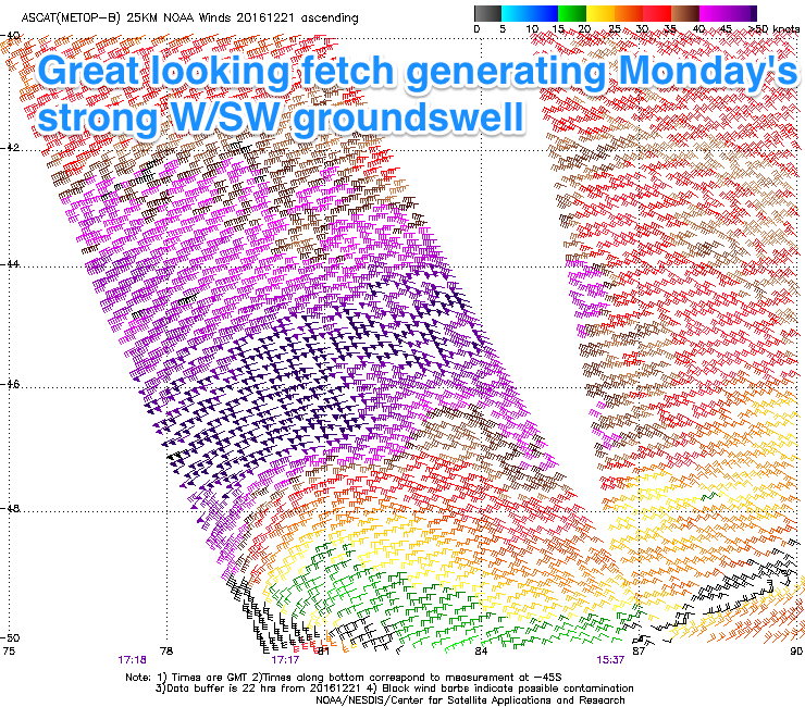
Our strong but inconsistent W/SW groundswell due Boxing Day is on track with satellite observations confirming a fetch of severe-gale to storm-force (up to 55kt) winds produced in our far western swell window.
The low generating this fetch has since weakened and will continue to weaken while stalling south-west of WA today and tomorrow.
A strong long-period but slightly inconsistent W/SW groundswell is due to arrive overnight Sunday and peak through Monday to 2ft on the Mid Coast (possibly the odd bigger set on the incoming tide) and 3-4ft across Middleton down South.
The stalling and slowly weakening nature of the low should see the swell ease slowly through Tuesday from 3ft down South at Middleton and 1-2ft on the Mid Coast.
Winds on Monday are a little tricky with a tropical low moving down from the North West due to bring a gusty S/SE change at some stage, but before this we may see variable winds across both coasts.
Tuesday should then see E'ly winds as the low continues dropping south (E/NE across Middleton) and then N/NW winds on Wednesday but with no major size left across the state.
Longer term the outlook is quite active with another good W/SW groundswell due late week from a slightly weaker front pushing through the southern Indian Ocean, along with a close-range W/SW swell from the system re-intensifying in the Bight. More on this Monday though as the models are divergent.
Have a Merry Christmas and great weekend!
Comments
Couple of rogue sets this morning...
Mid Coast looking great this morning!
Alright! Now we're torkin.
Pumping!
Couple of solid sets earlier.