Great clean conditions tomorrow, good W/SW swell for Wednesday but onshore

South Australian Forecast by Craig Brokensha (issued Monday 19th September)
Best Days: South Coast tomorrow, Mid Coast keen surfers Wednesday and Thursday morning, South Coast Friday
Recap
A small clean start to Saturday but the swell built through the day as winds remained offshore until mid-afternoon. Sunday saw plenty of size but poor conditions with fresh onshore winds.
The Mid Coast was tiny and bumpy Saturday, while a kick in size to 1-2ft was seen yesterday with workable S'ly winds.
Today conditions were cleaner down South with an offshore wind and mix of new building swells. We should see Middleton building to 3-4ft as winds remain offshore all day, while the Mid will remain around 1-1.5ft.
This week (Sep 20 - 23)
Winds have changed for tomorrow across the South Coast with a tricky trough expected to stall to our west during most of tomorrow.
This will direct fresh N/NE winds across the coast most of the day before giving into a late onshore change, likely after dark.
This afternoon's increase in SW groundswell should ease back from the 3ft range at Middleton and 4-5ft at Waits and Parsons.
The Mid Coast is expected to be around 1-1.5ft, but later in the day, a new W/SW groundswell may be seen. This will be as winds swing onshore though, with Wednesday a better chance to surf with the new swell.
This swell was generated by a strong front piggy-backing over the top of the polar low generating today's SW swells, with a fetch of W/SW gales projected up towards WA and through the Bight.
This has generated a moderate to large W/SW groundswell that should peak Wednesday morning to 2-3ft on the Mid Coast and 3-5ft along the Middleton stretch. Unfortunately winds will be poor and onshore from the S/SW, creating average conditions across both coasts. Protected spots on the Mid are the only option.
 Unfortunately onshore winds look to possibly linger into Thursday morning creating average conditions down South as the swell eases, while the Mid Coast might see an S/SE breeze early with easing 1ft to maybe 2ft sets.
A slight pulse of small SW groundswell is due Friday from a less than favourably aligned and south-east tracking mid-latitude front from WA. This should keep small 2ft waves hitting Middleton with 3-4ft sets at Waits and Parsons before easing into Saturday. The Mid isn't due to see much above 1ft.
Clean conditions are due though with N/NE winds Friday and then fresh N'ly winds Saturday morning ahead of a gusty W/SW change.
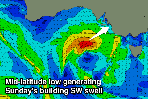
This change will be linked to a small and intense mid-latitude front pushing towards us from the west-southwest, kicking up a new SW swell for Sunday. Size wise we could see Middleton building to 3-4ft+ with 2ft sets on the Mid but with W/SW winds. We'll look at this in more detail on Wednesday.