Good swell and winds for both coasts Sunday, great South Coast early next week

South Australian Forecast by Craig Brokensha (issued Friday 12th August)
Best Days: Sunday both coasts, South Coast Monday and Tuesday, Mid Coast Wednesday
Recap
Bumpy average easing 2-3ft waves across the Mid Coast yesterday, improving a bit into the afternoon as winds tending more N/NW and eased.
The South Coast was solid and workable early before winds shifted onshore and remained so until easing late afternoon creating some fun ones for the late session.
This morning was the pick though with clean straight 3-4ft sets off Middleton while the Mid was back to a small and bumpy 1-2ft. The surf has eased and a stronger NW winds is creating tricky conditions.
This weekend and next week (Aug 13 - 19)
Tomorrow we'll fall between swells with leftover 2ft to sometimes 3ft waves along the Middleton stretch and 1-1.5ft sets on the Mid. Conditions will be average on the Mid and best down South with a W/NW breeze.
Out strong pulse of W/SW groundswell for Sunday is still on track, with an initial mid-latitude low firing up south-west of WA setting in motion an active sea state for a much better fetch of severe-gale pre-frontal W/NW winds to move over, then followed by severe-gale W/SW winds.
This should generate a moderate to large W/SW groundswell for Sunday, peaking through the middle of the day.
The Mid Coast is expected to see strong 2-3ft sets with 4-5ft waves at Middleton and larger bombs out at Waits and Parsons.
Conditions will be best down South again with a NW tending variable wind. The Mid should be workable all day with a light N'ly tending variable breeze.
 The surf will drop back through Monday under offshore N'ly winds down South, N/NE hopefully on the Mid.
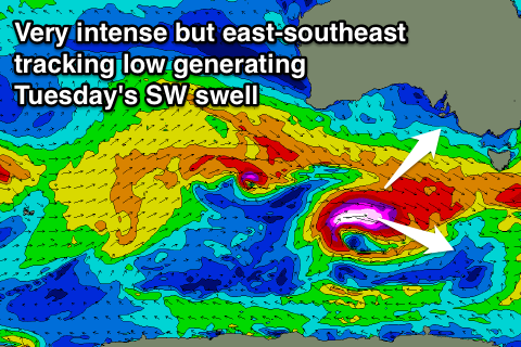
Another strong pulse of long-period SW groundswell is due early Tuesday across the state, produced by an intense low firing up on the back of the weekend's activity.
The low will track less than favourably to the east-southeast but winds will reach the storm-force range, overcoming this somewhat.
Middleton should offer strong 3-4ft sets again Tuesday morning with 6ft surf at Waits and Parsons, while the Mid won't see much size at all with fading 1-2ft sets. Slightly stronger N/NW winds are due Tuesday morning, tending lighter W/NW through the afternoon.
Plenty more W/SW swell is due into Wednesday/Thursday and the following weekend, but we'll have another look at this Monday. Have a great weekend!
Comments
Nice Victor corduroy this morning.