Poor outlook with lots of swell late week but terrible conditions

South Australian Forecast (issued Monday 25th December)
Best Days: Exposed breaks South Coast Wednesday morning
Recap
Poor onshore winds and easing levels of swell all weekend, with no quality options for a surf down South. The Mid was cleaner but tiny.
Today poor conditions have continued with a S/SE windswell also in the mix down South.
This week (Jan 26 - 29)
South Coast: Tomorrow will continue to be average down South with moderate to fresh SE winds, possibly tending more E/SE through the morning along with an average mix of SW and S/SE windswell to 2ft at Middleton and 3ft at Waits and Parsons.
Wednesday will become cleaner as a surface trough over Victoria responsible for the poor SE winds drifts a touch west. This should result in variable tending light offshore N'ly winds ahead of a shallow SW change.
The swell will be small and easing though with fading 1-1.5ft sets at Middleton and 2ft+ sets at Waits and Parsons.
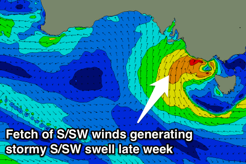 Wednesday afternoon's shallow change will be linked to a weak front pushing up from the Southern Ocean. A fetch of strong S/SW winds are due to be projected up into the South Coast through the day Thursday, persisting Friday and easing Saturday as the front is absorbed into a broader low pressure system.
This will kick up moderate amounts of S/SW windswell building later Thursday from a tiny onshore dribble in the morning, peaking Friday afternoon to a stormy 4-5ft+ across most locations, but along with strong SW winds.
Mid Coast: A small and inconsistent pulse of SW groundswell tomorrow may offer inconsistent 0.5-1ft sets on the favourable parts of the tide, and winds should be decent all day.
The swell is then due to fade Wednesday ahead of some building windswell later Thursday maybe to 1ft+, peaking out of the south Friday afternoon to 1-1.5ft, easing from a similar size Saturday morning.
This weekend onwards (Jan 30 onwards)
South Coast: Friday's solid and stormy increase in S/SW windswell will ease slowly Saturday and more so Sunday as the low generating the swell weakens and pushes slowly east. Conditions will remain poor though with S'ly winds Saturday, possibly more variable Sunday morning.
The Mid Coast will become tiny over the weekend with bumpy average conditions Saturday.
Longer term a strong mid-latitude low may develop in the Bight next week, generating some solid swell for later next week, but more on this Wednesday.