Average week with a variety of swells and conditions

South Australian Forecast (issued Monday 2nd November)
Best Days: Wednesday small waves South Coast, Sunday similar
Recap
Small clean waves Saturday morning with light variable winds and the most size out at Waits and Parsons. The Mid was tiny and slightly bumpy. Sunday was similar with early light winds and a small fun swell, before a fresh and strengthening S/SW change moved through.
Today the surf was bottoming out with early light winds again, but a strong S/SE change has since moved through whipping up a building and weak S'ly windswell. A slight kick in new swell should be seen on the Mid this afternoon, but only to 1ft+ if we're lucky.
This week (Nov 3 - 6)
South Coast: A new mix of SW and S/SW swell are due across the South Coast tomorrow, but it seems like the models are over-forecasting the size. The swells were generated by an unfavourably south-east tracking but strong front from under WA, down towards the polar shelf and under Tassie.
Middleton should see 2-3ft peaks with a SE windswell also in the mix, and 3-4ft sets at Waits and Parsons, easing through the afternoon and bottoming out through Wednesday and Thursday.
Winds aren't looking to favourable tomorrow with a fresh to strong E'ly (possibly E/NE at times) creating peaky and choppy conditions at most breaks.
Wednesday should be cleaner as a low sitting to our west starts to drift south-east bringing NE tending NW winds. Unfortunately there'll be no real swell left with 2ft of S/SE windswell across most breaks.
Thursday should then be OK early with a W/NW offshore ahead of a SW change through the day, but the swell non-existent again with a tiny mix of smalls likely to only 1-2ft or so.
Into Friday we've got a mix of new long-period and inconsistent SW groundswells due. The longer-range SW energy was produced in our far swell window and isn't expected to offer any real size, but the closer-range SW swell should be generated at polar latitudes south of WA during the coming days.
A good kick to 3ft should be seen at Middleton during the afternoon with 4-5ft sets at Waits and Parsons but onshore S/SW winds look to spoil the party. There is the chance for an early W'ly around Victor, but we'll review this again on Wednesday.
Mid Coast: This afternoon's slight kick in swell is due to fade back through tomorrow from a tiny 0.5-1ft. Tiny to flat surf is then due for the rest of the week, with a weak SW windswell for Thursday only to 0.5-1ft, continuing Friday with the inconsistent SW groundswell energy.
 This weekend onwards (Nov 7 onwards)
South Coast: Friday's SW swells are due to ease back through Saturday but conditions will remain poor with a fresh E/SE wind. Sunday looks to be clean with offshore N/NE winds but the surf will be small and fading from 1-2ft, with 2-3ft sets at Waits and Parsons.
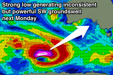
Longer term an inconsistent but strong SW groundswell is due Monday across the state, from a vigorous polar low firing up south-west of Western Australia later this week. We're probably looking at 3-4ft surf at Middleton, but we'll have another look at this on Wednesday.
Mid Coast: Nothing to really surf over the weekend with tiny clean waves, while Monday's swell only looks to be in the 1ft+ range. More on this Wednesday.