Average until the end of the week and more so the weekend

South Australian Forecast (issued Monday 19th October)
Best Days: Protected spots for keen surfers tomorrow morning down South, South and Mid Coasts keen surfers Friday morning, South Coast Saturday and Sunday
Recap
 Average onshore waves Saturday across the South Coast with better 1-2ft waves across the Mid, cleanest through the morning and later in the day.
Sunday saw the arrival of a strong W/SW groundswell with the Mid pulsing to 2ft to occasionally 3ft on the sets, while the South Coast also saw solid size reaching 3-5ft across Middleton with bigger bombs out at Waits and Parsons. E/NE tending NE winds creating fun conditions through the morning before S/SE sea breezes kicked in.
Today the swell was easing from 1-1.5ft on the Mid, while the South Coast continued to offer solid and cleaner 3-4ft waves across the Middleton stretch, but a steady easing trend has since been seen.
This week (Oct 20 – 23)
South Coast: Tomorrow is looking dicey with small leftovers after today's swell continues to ease, and winds are an issue with a freshening W/NW'ly expected to strengthen through the day, favouring only protected spots. Unfortunately only 1-2ft waves are due across Middleton with 2ft+ sets at Waits for keen surfers.
 Wednesday will be poor with fresh to strong SW tending S/SW winds in the wake of an overnight onshore change, kicking up a junky 3ft of windswell.
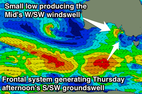
This windswell will then ease back through Thursday ahead of a better S/SW groundswell from the initial stages of the polar frontal system linked to Wednesday's onshore change.
This polar frontal system is currently south-west of WA, generating a fetch of W/SW gales which are forecast to be projected towards Victoria over the coming days.
A moderate sized S/SW groundswell should be produced, building later Thursday to 3-4ft at Middleton and 4-5ft at Waits and Parsons, easing from a similar size Friday morning.
Conditions will remain poor Thursday though with a moderate to fresh E/SE tending S/SE breeze, while Friday will be slightly better with morning E'ly breezes (possibly tending E/NE) ahead of the sea breeze.
Mid Coast: Tomorrow's strengthening W/NW winds will be linked to a small and strengthening low pushing through the Bight, with this expected to kick up 1-2ft of W/SW windswell tomorrow afternoon, easing from 1-2ft Wednesday morning.
The S/SW groundswell for later Thursday and Friday aren't due to provide any major size with 1-1.5ft tops due across swell magnets.
This weekend (Oct 24 onwards)
South Coast: Fun surf is due down South over the weekend, with Friday's swell dropping away steadily under NE winds Saturday morning and N/NE tending N/NW breezes Sunday.
Into next week a new S/SW swell is on the cards for Tuesday but with poor S/SE winds, possibly becoming cleaner as it eases Wednesday.
Mid Coast: Tiny clean surf is due Saturday with near flat and wind affected conditions Sunday as winds tend more onshore.