Fun South Coast tomorrow morning, great swell for Sunday

South Australian Forecast (issued Wednesday 14th October)
Best Days: Thursday morning down South, Sunday both coasts, Monday both coasts (best down South), early Tuesday down South
Recap
Poor wind affected waves across the South Coast yesterday with clean 1ft waves on the Mid for most of the day. Today the South Coast was much cleaner but small with Waits and Parsons the pick for the best waves. The Mid was also clean but back to 0.5ft.
This week and weekend (Oct 15 – 18)
South Coast: Tomorrow morning is looking fun again with a new SW swell to 2ft at Middleton and 3ft to occasionally 4ft at Waits and Parsons under fresh to strong N/NW winds. Winds are expected to turn funky through the afternoon with a shallow change trying to push through. This may result in winds just tending variable, but a morning surf would be advised.
Come Friday a mix of very inconsistent long-range SW groundswell and closer-range SW swell are due, but the change proper will move through, creating poor conditions with SW tending S/SW winds.
The models are over-forecasting the size in any case, with only small 2ft surf due to continue across Middleton, with 3-4ft sets at Waits and Parsons. Similar sized surf is due into Saturday morning as winds remain average and from the S'th.
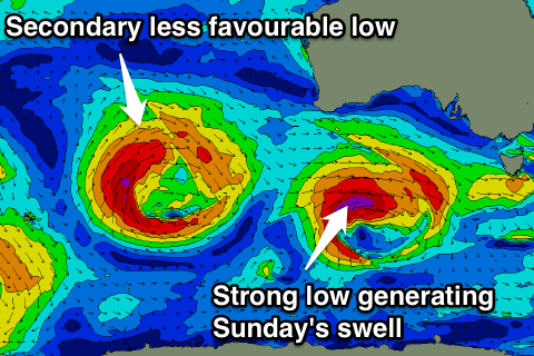 Our strong pulse of SW groundswell for Sunday is still on track (being more W/SW than SW now), with a vigorous low forecast to develop south-west of WA tomorrow before pushing east and aiming a fetch of gale to severe-gale W/SW winds towards Victoria.
A moderate to large W/SW groundswell is now due, peaking Sunday to a solid 4-5ft across Middleton with 6ft+ sets at Waits and Parsons under morning E/NE-NE winds (not the best combo).
Mid Coast: Thursday's swell should come in at 0.5-1ft but conditions will be bumpy with those N'ly winds. A late glass-off is possible if the change is weak enough. Come Friday tiny onshore waves won't be worth the effort.
Sunday's SW groundswell should provide some really fun waves across the coast, with 2ft surf due most of the day, with the odd bigger one a chance on the large incoming tide.
Next week onwards (Oct 19 onwards)
South Coast: Sunday's swell is expected to ease back through Monday with straighter offshore N/NE tending variable winds. Middleton should still offer 3-4ft sets through the morning with 5ft bombs at Waits and Parsons, smaller into the afternoon and Tuesday.
Our secondary pulse of W/SW groundswell due for Tuesday/Wednesday has unfortunately been downgraded with the secondary low producing the swell weakening off the WA coast, and not being too favourably aligned. This swell due later Tuesday and Wednesday morning will hardly produce any major size down South, but winds are due to be favourable early Tuesday with onshores Wednesday.
Mid Coast: Sunday's swell is expected to drop back from 1-1.5ft Monday, with the inconsistent W/SW groundswell for later Tuesday possibly providing 1ft+ sets, before easing from a similar size, but with those poor winds.
Longer term some good SW groundswell is likely into the end of the wind, but more on this Friday.