Wednesday morning the pick, then improving weekend

South Australian Forecast (issued Monday 24th August)
Best Days: Wednesday morning for keen surfers South Coast, Saturday morning, Sunday
Recap
Tiny clean waves across the South Coast Saturday suited to exposed coasts, with a slight uptick in size for Sunday as favourable winds continued through the morning. The Mid Coast offered improving 1-1.5ft waves Saturday and was around a cleaner 1-1.5ft Sunday.
An onshore change around midday yesterday has strengthened into today with a junky mix of SW and SE swells across the South Coast with poor conditions. The Mid was clean but back to a micro 0.5ft.
This week and weekend (Aug 25 - 30)
As touched on the last few update, there's plenty of swell due across the coast this week, but persistent SE winds will be the fly in the ointment.
Today a mix of building SW groundswell and S/SE windswell will both ease through tomorrow but with fresh S/SE winds.
A window of cleaner conditions is still on the cards for Wednesday as a strong new S/SW groundswell fills in.
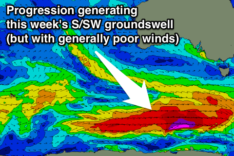 This groundswell is being generated by a strong and elongated polar frontal progression under the country, with a solid kick in size due through the middle of the day to 3-5ft at Middleton and up 6ft at Waits and Parsons while the Mid will only see 0.5-1ft sets.
Winds are likely to tend variable through the morning if not light NE as a small surface trough slips south across the region. This won't create amazing conditions with lumpy/wobbly waves due, but will open a window for a surf through the morning, before onshores kick back in again during the afternoon.
Thursday and Friday will be write-offs with fresh to strong S/SE winds kicking in again kicking up new levels of weak windswell, and then SE winds Friday.
The weekend should see conditions improving slowly, with Sunday being the best of the bunch.
A mix of swells is due Saturday to the 2-3ft range at Middleton and 3-5ft at Waits with E/NE tending SE winds.
Sunday will start small, fun and clean with a better N-NE breeze, ahead of a late afternoon kick in new long-range and inconsistent SW groundswell energy.
This long-range swell will be generated over the coming days by a very strong and powerful frontal progression in the Indian Ocean, generating large swells for Indonesia, but only offer limited size here across our state.
A late kick to 3-4ft is expected across Middleton Sunday with 5-6ft sets at Waits and Parsons but with winds swinging more E'ly.
Monday will see the swell drop away under strong offshore N'ly winds ahead of a W'ly change, which is less than ideal.
Longer term a cut-off low moving in from the west early next week may provide some junky windswell but there's nothing much beyond that. We'll have a closer look at this Wednesday though.