Make the most of the next few days

South Australian Forecast (issued Wednesday 19th August)
Best Days: Thursday afternoon down South and Friday morning, Saturday Mid Coast and South Coast during morning, Sunday morning South Coast for keen surfers in protected spots
Recap
Solid easing waves with some slight lump and wobble across the South Coast yesterday morning, dropping from 3-5ft at Middleton. The Mid Coast was also clean with tiny 1ft sets.
Today the swell was smaller with fresher NE winds favouring selected locations.
This week and weekend (Aug 20 - 23)
Tomorrow is due to still start tiny and clean with a strong N/NE wind, but the afternoon should see winds ease a touch and a strong new S/SW groundswell fill in, generated by a vigorous polar frontal system south-west of Tassie.
Middleton should kick to a solid 3ft to possibly 4ft during the afternoon with Waits and Parsons offering easy 5ft sets before dropping from Friday from 3ft at Middleton and 4-5ft at Waits early. Winds will remain tricky and fresh to strong from the N'th Friday morning before shifting NW and then W/NW into the afternoon.
The Mid Coast will be tiny Thursday but a new W/SW swell should build Friday generated by a cut-off low moving in from the west, aiming a weak fetch of W/SW winds through the Bight tomorrow and Friday. This should kick to 1-1.5ft along the Mid but with those poor onshore winds.
Into the weekend, The Mid should see better 1-2ft sets Saturday morning before easing into the afternoon and further Sunday. Our better W/SW groundswell for Sunday and Monday has been wiped off the charts unfortunately with the secondary cut-off low due to form in our swell window now drifting too high in latitude, riding inland across the Eyre Peninsula and then across us.
This won't bring any new swell at all and instead will bring strengthening SE winds from Sunday afternoon creating poor conditions down South.
 But back to Saturday and the easing W/SW swell will be met with moderate but easing NW tending W'ly winds. The South Coast should be small and fun and best through the morning. Sunday morning will be only for desperate surfers with a leftover swell and fresh E/NE tending SE breeze.
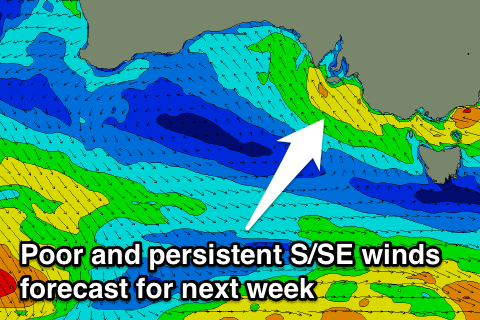
Next Monday onwards (Aug 24 onwards)
The surface trough drifting across us Sunday bringing the strengthening SE winds will stall off the East Coast through next week, directing a persisting fetch of strong S/SE winds into us all week.
This will kick up solid levels of windswell but with poor conditions, while there'll also be some good SW groundswell in the mix, but to no major size on the Mid. Therefore make the most of the coming days of waves before winds go bad Sunday afternoon.