Fun South Coast over coming days, very large and onshore early next week

South Australian Forecast (issued Wednesday 29th July)
Best Days: Thursday and Friday down South, Saturday afternoon both coasts, Sunday morning South Coast, Monday novelty spots for keen surfers down South, early Tuesday and Wednesday down South
Recap
Great waves across the South Coast yesterday with a straight offshore and solid easing swell. The Mid was tiny and easing from the 1ft range.
This morning the swell has bottomed out across both coasts, with N/NW winds favouring exposed spots across the South Coast. A new late kick in SW groundswell is due, so keep an eye on the Middleton cam for signs of this.
This week and next week (Jul 30 – Aug 7)
The late kick in new SW groundswell due this afternoon, should peak overnight, but offer solid easing 3-5ft sets at Middleton and 5-6ft+ waves at Waits and Parsons early, down through the day. The Mid is due to ease from 1-1.5ft.
The morning will be best as fresh to strong N/NW winds, swing more W/NW through the day ahead of a late onshore SW change.
This change will be related to a weakening front pushing through but this should produce a reinforcing SW swell for Friday to 3ft+ at Middleton and 5ft at Waits and 1ft on the Mid. Early light N'ly winds should swing NW through the day, creating great fun surf all day.
 From Saturday through until the middle of next week at least we're due to see large amounts of groundswell impacting mainly the South Coast, as a strengthening node of the Long Wave Trough moves in from the west and stalls across the south-east of the country.
This will direct front after front after front up and through mainly our south-western swell window, with the first firing up south-west of WA this evening and projecting towards us over the coming days.
This should produce an initial large pulse of SW groundswell for the weekend, building Saturday, peaking overnight and easing Sunday.
Middleton should build from around 3ft+ early Saturday with 5ft sets at Waits and Parsons and 1ft waves on the Mid, to a strong and large 5-6ft and 6-8ft respectively. The Mid should kick to 1-2ft and winds are due to improve across both coasts with an early fresh SW'ly, easing rapidly and tending variable into the afternoon.
Sunday will then see strengthening W/NW winds ahead of a strong W/SW change and easing swell from 4-6ft at Middleton and 6-8ft at Waits with 2ft waves on the Mid.
The secondary frontal system to fire up towards us is due over the weekend, and this will be stronger, with a fetch of severe-gale W/SW-SW winds aimed through our south-western swell window.
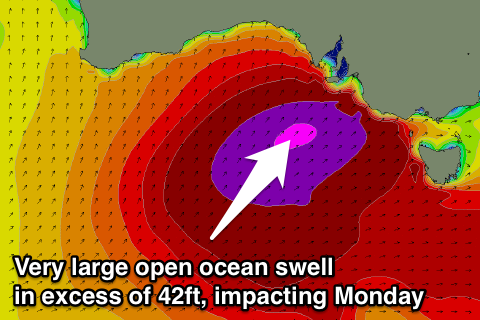
This should produce a strong, large long-period SW groundswell which may be seen late Sunday, but will peak Monday. On top of this though, a piggy-backing frontal system will project a fetch of SW gales right towards the South Coast Sunday evening, increasing the large swell further.
Come Monday we're due to see large 8-10ft waves across the Middleton stretch with larger bombs at Waits and Parsons under strong but easing SW winds. This will also kick up 3-4ft of swell on the Mid, which will ease through the day as winds ease. Options will be severely limited to novelty breaks though down South.
The swell should ease through Tuesday and further Wednesday as winds improve, possibly tending W/NW Tuesday and Wednesday mornings down South. We'll have a closer look at this Friday.