Lots of swell to come, with workable conditions

South Australian Forecast (issued Friday 24th July)
Best Days: Saturday down South, both coasts Sunday, protected locations down South Monday and Tuesday morning, Wednesday down South, Thursday down South
Recap
Great waves across both coasts yesterday with a clean 2ft wave across the Mid most of the day, and 3-4ft sets at Middleton and larger bombs at Waits for experienced surfers.
Today, winds are more W'ly and the swell holding a bumpy 2ft on the Mid, with smaller 2-3ft sets across the Middleton stretch and larger wind affected waves at Waits.
This weekend and next week (Jul 25 - 31)
Both tomorrow's increase in W/SW swell across the South Coast and then groundswell for Sunday have been upgraded in size.
Firstly a strengthening frontal system pushing into us this evening should produce a good W/SW groundswell tomorrow to 3ft+ at Middleton and 5ft at Waits and Parsons with fresh to strong NW tending W/NW winds.
 The Mid Coast will see plenty of size with 2-3ft waves through the morning, persisting into the afternoon with a building stormy swell as winds increase.
Come Sunday the Mid should ease from a stormy 3-4ft with strong but easing SW winds, while the South Coast will offer large surf, as the frontal system pushing into us from the west, aims a fetch of severe-gale to storm-force SW winds through its swell window.
Middleton should see easy 6ft+ sets with 8ft+ waves at Waits and offshore reefs, but with strong early W'ly tending weaker W/SW winds. So protected locations will be the only real option.
Monday will remain large down south, as a secondary pulse of large S/SW groundswell keep wave heights up through the morning. This will be from a fetch of severe-gale SW winds on the backside of the low/front Sunday.
This should see Middleton easing from the 6ft range with 8ft sets at Waits, dropping further into Tuesday and Wednesday morning. The Mid should ease from 2ft Monday morning and become tiny to 1ft+ Tuesday.
Winds on Monday will be workable in protected locations down South again with an early W/NW'ly, tending back to the SW through the day. The Mid may see more variable winds during the morning but I wouldn't count on it.
Tuesday looks to play out similarly but with smaller amounts of swell.
Wednesday will be the cleanest of the low with offshore N/NW winds, favouring the South Coast.
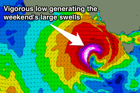
A new SW groundswell for Wednesday afternoon, and then stronger pulse for Thursday are still on track, generated by a vigorous polar frontal progression firing up in the Heard Island region Saturday and pushing east through Sunday and early next week.
Thursday's should peak to an inconsistent 4-5ft at Middleton with 6ft+ sets at Waits and Parsons and 1-1.5ft waves on the Mid as N/NW winds persist.
Longer term a larger SW groundswell is possible for next weekend, but we'll have a closer look at this on Monday. Have a great weekend!
Comments
Ain't small at Victor today. Winds are good too!