Fun clean waves over the weekend, more swell next week

South Australian Forecast (issued Friday 15th May)
Best Days: Saturday, Sunday, Tuesday
Recap
Workable waves early across the South Coast with a drop in the onshore wind and solid swell providing good waves around Victor Harbor. The wind kicked in again through the day though creating poor conditions into the afternoon.
The Mid was a weak and lumpy 1-1.5ft with an early offshore wind before easing further into the afternoon.
Today the South Coast was cleaner with a lighter E'ly breeze and still plenty of size and south in the swell to open up options from Victor to Goolwa, while the Mid was clean but tiny.
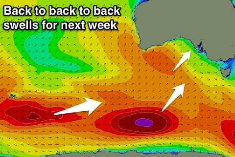 This weekend and next week (May 16 - 22)
This weekend and next week will be super fun across the South Coast with favourable winds and small to moderate pulses of swell.
Today's solid S'ly swell across the South Coast should ease back steadily this afternoon and further into tomorrow morning leaving 2ft waves at Middleton with 3ft sets at Waits and Parsons.
A good new S/SW groundswell is due to build through the day though, reaching 3ft on the sets across Middleton with 3-4ft waves at Waits and Parsons with morning NE winds ahead of a SE'ly into the afternoon.
The swell should drop through Sunday from 2ft to nearly 3ft at Middleton and 3ft to occasionally 4ft across Waits and Parsons under N/NE tending E'ly winds.
Monday will be super clean with a fresh N/NE'ly but the swell will become tiny.
The outlook for the rest of next week is good with pulse after pulse of S/SW and SW groundswell along with initially favourable winds.
This will be due to the westerly storm track being restricted to the poles while maintaining steam, with a series of back to back and vigorous polar lows due to fire up in our swell window.
An initial first and strong system over the weekend should produce a primary S/SW pulse that should be seen Tuesday with 3ft sets due across Middleton with 3-4ft waves at Waits under a N/NW tending variable breeze.
A secondary broader system will develop later Sunday and project north-east towards us into Monday producing a stronger SW groundswell for Wednesday that's due to arrive later in the day and peak Thursday morning to 3-4ft at Middleton and 4-5ft at Waits and Parsons with 1-2ft waves on the Mid.
Winds will unfortunately take a turn for the worse Thursday as a mid-latitude low pushes in from the west bringing and onshore S'ly change that is expected to persist into Friday from the SW.
During Friday the largest pulse of S/SW groundswell is also due, produced by the strongest polar low of the lot, generating a fetch of severe-gale to storm-force W'ly winds along the polar shelf next week.
This should produce larger 4-5ft waves at Middleton once it fills in Friday with 6ft sets at Waits but with those poor SW winds.
The weekend looks to become cleaner and further pulses of swell are due, but we'll discuss this more on Monday.
Comments
0.3m NW swell..thats a lot of backwash!!