Small to tiny ahead of some better swell from Friday

South Australian Forecast (issued Monday 13th April)
Best Days: Tuesday swell magnets, late Thursday on the Mid for beginners, both coasts Friday, dawn Saturday down South, Mid Coast Sunday
Recap
Great conditions for exposed breaks Saturday morning with a small easing swell and offshore breeze, Sunday was less than ideal with the small swell continuing under a light onshore wind that then freshened through the day.
Today a new rare S'ly groundswell has filled in down South with offshore winds and similar sized waves at Middleton to Waitpinga and Parsons due to the swell hitting straight on.
 This week (Apr 14 – 17)
Conditions will be great tomorrow and good Wednesday morning but unfortunately today's pulse of S'ly swell will fade away with the coast expected to become small to tiny.
Waits and Parsons will be your best bet tomorrow for small clean waves, while Wednesday will be ideal for beginners at Middleton before a a weak onshore change moves through during the afternoon.
Thursday will be a lay day with a small to tiny swell and fresh onshore SE tending S/SE breeze. The Mid may see a late kick in size to 1ft Thursday from a weakening front pushing through the Bight tomorrow, providing good beginner waves on the beaches.
Of greater importance is a stronger but inconsistent W/SW groundswell linked to this weakening front, generated in the southern Indian Ocean over the weekend and today.
This swell will be very inconsistent but should peak Friday morning to 2ft on the Mid with 3ft sets at Middleton and 4-5ft waves at Waits and Parsons.
A stronger increase in SW swell should show through the afternoon though, holding into Saturday morning, generated by a secondary polar low under the influence of the Long Wave Trough firing up south-west of WA tomorrow.
A fetch of severe-gale W/NW and then W/SW winds will be aimed through our south-western swell window, generating a larger and more consistent groundswell for Friday afternoon and Saturday morning.
The Mid should see better 2ft+ sets on dark Friday before easing from 2ft Saturday morning while the South Coast should build to 3-5ft at Middleton and 6ft at Waits, dropping back from 3-4ft and 5-6ft respectively Saturday morning.
Winds will be great for both coasts Friday morning and variable tending locally offshore before tending NW through the afternoon.
Saturday looks best down South at dawn with a fresh and early W/NW'ly ahead of a strong SW change mid-morning.
This weekend onwards (Apr 18 onwards)
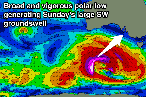
Saturday afternoon's change will be linked to a vigorous and broad polar low pushing in from the west later in the week, aiming a fetch of severe-gale to storm-force W/SW to SW winds through our swell window, generating a large and powerful SW groundswell that should kick later Saturday and peak Sunday morning.
This swell will be the strongest we've seen in quite a while with the Mid due to come in at a solid 3ft, with the South Coast pulsing to 6ft+ at Middleton and 8ft+ at Waits and Parsons but winds may be a problem down South and onshore from the S'th. The Mid looks cleaner though as well as other selected breaks. More on this Wednesday though.