Good Mid Coast swell from late Thursday through Saturday morning

South Australian Forecast (issued Wednesday 12th November)
Best Days: Mid-late morning exposed spots down South tomorrow, late in the day on the Mid, Friday through Saturday morning on the Mid, Monday morning and Tuesday morning down South
Recap
Yesterday was still fun on the Mid through the morning with a clean 1-2ft of easing swell. The South Coast offered plenty of swell but less than perfect conditions with a fresh E'ly breeze before S/SE sea breezes kicked in.
Today was much better down South with a morning offshore wind and good 3ft of swell along the Middleton stretch, with bigger better waves out at Waits and Parsons. The Mid Coast was a clean and tiny 1ft, but sea breezes have since moved in across both coasts.
 This week and weekend (Nov 13 – 16)
This morning's good fun S/SW swell across the South Coast will ease through this afternoon and fade through tomorrow with varying winds. Early conditions won't be great with an E/NE breeze, but a swing to the N'th is due through the morning before tending variable into the afternoon, so mid-late morning will be the pick before the swell becomes tiny.
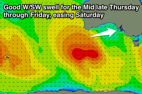
The Mid will be tiny early, but a strong new W/SW groundswell is due to arrive later in the day, generated by a low dipping south-east from the Southern Indian Ocean past the south-west of WA and now weakening.
This low performed a little better than forecast Monday and should provide good 1-2ft sets later tomorrow on the Mid and hold in at 2ft through all of Friday before easing from 1-2ft Saturday morning.
Winds will be good but a little blustery with a strong SE tending S/SE breeze Friday and then offshore E/SE winds ahead of a S/SW change during the afternoon Saturday.
These strong S/SE winds will kick up a poor quality windswell across the South Coast through Friday before easing Saturday but there'll be no decent options for a surf.
Come Sunday winds will shift back to the W/SW across both coasts, with the South Coast possibly seeing a period of morning W/NW winds. This will meet a new S/SW groundswell that should be generated by a relatively weak polar front pushing up and into Tassie Friday.
Middleton should offer 3ft sets, while Waits and Parsons are due to be around 4ft. The Mid will be a bumpy 1ft or so.
Next Monday onwards (Nov 17 onwards)
Next week is looking a little more healthier in the surf department as a series of strong polar fronts deliver some decent pulses of swell and good winds.
Firstly a small to moderate S/SW groundswell should fill in later Monday and then ease Tuesday, generated by another relatively weak but favourably tracking front over the weekend.
Monday morning should be clean with a light NW wind on the South Coast, but sea breezes will spoil the late kick in size. Tuesday morning will be best as the swell eases from 3ft+ at Middleton and 3-5ft at Waits under morning N/NE winds.
Into Thursday afternoon a strong new long-range SW groundswell is likely ahead of a secondary larger W/SW groundswell over the weekend, but more on this Friday.