Mid Coast Sunday, South Coast Monday

South Australian Forecast (issued Friday 31st October)
Best Days: Sunday on the Mid, Monday down South, later Wednesday on the Mid, Thursday on the Mid, Friday down South
Recap
Light winds and a good sized swell provided fun waves across the South Coast yesterday morning while the Mid Coast saw clean 1-2ft sets before afternoon sea breezes spoilt conditions into the afternoon.
A strong new S/SW groundswell has filled in today across the South Coast with 3-4ft+ sets across Middleton with larger bombs out at Waits and Parsons under fresh and gusty N/NE winds which has since shifted stronger NW with a drop in size.
 This weekend (Nov 1 – 2)
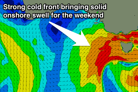
Unfortunately the weekend isn't looking too flash, with a late onshore W/SW change due this evening expected to push through with much greater strength around dawn tomorrow bringing fresh to strong W/SW tending SW winds across both coasts.
With this change though we'll see another large spike in S/SW swell across the South Coast, and SW windswell across the Mid, building Saturday and peaking Sunday morning (down South).
The Mid tomorrow should see semi-stormy 2ft waves developing through the day, before easing from 2ft Sunday.
The South Coast should see the S/SW swell peaking Sunday morning to 4-5ft across Middleton with 6ft sets at Waits and Parsons, but conditions will be poor with fresh but easing S'ly tending S/SE winds. Therefore the Mid Coast Sunday morning will be the pick of the weekend.
Next week onwards (Nov 3 onwards)
Monday is the pick of the week with Sunday's solid S/SW swell expected to ease quickly under offshore N/NE winds. Middleton should drop steadily from 3-4ft, with 5ft sets at Waits, while the Mid will be tiny.
Early Tuesday morning should be clean down South with an offshore N/NW breeze ahead of a trough and S/SW change late morning/midday but there won't be much swell left at all, with tiny waves at Middleton and the odd 2ft set at Waits.
Wednesday will be a write-off as well with small to tiny amounts of swell and onshore S/SE winds, but a new long-range W/SW groundswell due late Wednesday, peaking Thursday should offer small clean peelers on the Mid.
This swell will be an inconsistent and long-range one, produced by a strong but patchy frontal system pushing up towards WA over the weekend and then through the Bight while weakening Monday.
The Mid should build to an inconsistent 1-2ft later in the day Wednesday and then ease gold 1-2ft Thursday before fading Friday.
The South Coast will see a touch more size, but conditions poor with E/SE tending SE winds.
Friday will be better for the South Coast but small and easing from 2ft+ at Middleton and 3-4ft at Waits under fresh N/NE winds. Longer term the outlook is poor with small to moderate amounts of swell and persistent onshore S'ly winds. Therefore make the most of the windows of decent waves coming up over the coming period and have a great weekend!