Great weekend down South, small windows next week

South Australian Forecast (issued Friday 12th September)
Best Days: Saturday, Sunday morning (late Sunday on the Mid), early Monday down South, Wednesday morning down South
Recap
A new W/SW groundswell offered bumpy but improving 2-3ft waves across the Mid Coast as onshore winds eased into the afternoon.
The South Coast was poor with fresh onshore winds swinging more S'ly during the day as the swell kicked in solidly.
Today was the day to surf across both coasts with a clean easing 2-3ft of swell on the Mid and solid 4-6ft surf down South with light local offshore winds.
This weekend and next week (Sep 13 - 19)
Today's swell should continue to drop away through tomorrow, easing from an inconsistent 1ft to possibly 2ft on the Mid, while the South Coast should drop from 3-5ft at Middleton with 4-6ft sets at Waits. Conditions will be great with light offshore N'ly winds (NE on the Mid) that should only tend variable if light onshore into the afternoon.
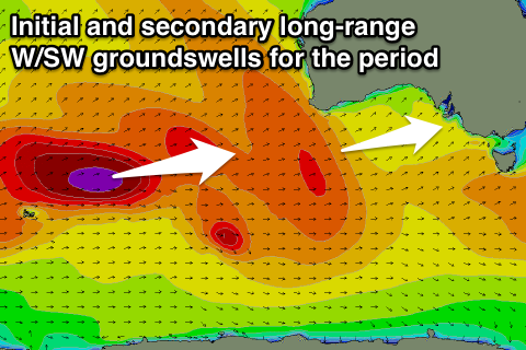
Sunday morning looks good as well, with a better swell for more exposed beaches down South with the swell continuing to ease under N/NE tending E/SE winds. The Mid Coast should be clean all day and a late increase in new long-range W/SW groundswell is due, with very inconsistent 2ft sets due towards dark ahead of a peak Monday morning to a similar 2ft.
This swell has been generated in our far swell window in the Southern Indian Ocean and will be very inconsistent but strong when it fills in, peaking Monday morning across both coasts.
 The South Coast should see very inconsistent 3-4ft sets at Middleton and 5ft bombs at Waits Monday morning but conditions will only be good for a short period at dawn as an early NW'ly ahead of a gusty S'ly change as a surface trough stalling in the Bight moves across us.
This will unfortunately create average conditions on the Mid, so aim for the late surf Sunday.
Monday's swell should ease into the afternoon and further Tuesday but winds will linger from the S/SW creating average conditions across both coasts.
Into Wednesday a secondary long-range W/SW groundswell from the Southern Indian Ocean is due, but the storm generating this swell isn't as large but will push a little closer towards us, producing a slightly smaller but more consistent swell than Monday's.
The Mid Coast should come in at 1-2ft again, while the South Coast will offer smaller 3ft waves at Middleton with 4ft+ sets at Waits but with W/NW tending SW winds, favouring semi-protected spots.
Longer term there's nothing too major on the cards heading into the end of the week and with dicey but workable winds. More on this Monday. Have a great weekend!