Fun waves from Saturday afternoon with excellent surf next week

South Australian Forecast (issued Friday 9th May)
Best Days: Saturday afternoon, Sunday, Monday onwards
Recap
Yesterday was great down South with an all day offshore and easing swell from 3ft at Middleton with better sets out at Waits.
Today the surf is small to tiny under a strengthening N/NW wind and this is kicking up a little NW windswell on the Mid Coast.
This weekend (May 10 - 11)
There's no rush to get down South early tomorrow as the morning will be tiny and clean, but a new W/SW groundswell is due into the afternoon as winds remain offshore from the W/NW.
This swell is being generated by a mid-latitude front slipping south-east across WA, aiming a burst of strong to gale-force W/SW winds through the Bight before continuing to slip south-east this afternoon.
Size wise Middleton should build to 2ft later with 3ft sets at Waits, but the Mid Coast should pulse to 2ft+ during the afternoon as winds back off from the W/NW. It won't be perfect but should be fun for a late afternoon surf.
The swell should hold a similar size into Sunday morning and winds will be great for both coasts, tending variable on the Mid while the South Coast should see NW tending variable winds, creating a full fun day of waves.
Monday onwards (May 12 onwards)
There's been no real change to the strong and powerful W/SW groundswell due across the state on Monday.
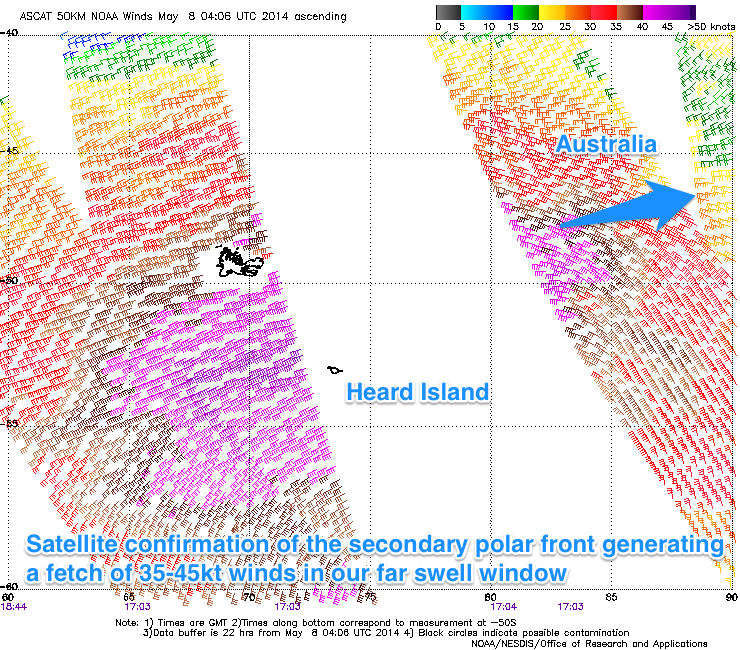 Satellite observations confirm two broad fetches of 35-45kt+ one after the other in the Southern Indian Ocean (pictured right), setting in motion two distinct pulses of swell. The first due to show size later Sunday probably won't be seen under the W/SW swell, but come Monday the stronger pulse should fill in and reach a very inconsistent 4-5ft at Middleton with 6ft sets at Waits into the afternoon. The Mid Coast should see inconsistent 2ft sets on the favourable parts of the tide.
Winds look great with a moderate offshore N/NE tending NE breeze expected down South and NE tending variable winds on the Mid Coast.
Come Tuesday the swell will slowly drop but this trend will be buffered by a series of tight, strong mid-latitude fronts generating reinforcing levels of W/SW swell.
Winds will remain excellent with a N/NE tending N'ly breeze down South, and this will probably be the pick of the week with an easing swell from 3-5ft at Middleton and 4-6ft at Waits.
Through the rest of the week we are expected to receive medium levels of W/SW groundswell under favourable winds. The reason for this is a strong blocking high over the continent in conjunction with a relentless series of polar fronts firing up towards WA before being deflected back the south-east by the high.
The biggest pulse is due Thursday afternoon and Friday morning back to 3-4ft at Middleton and 4-5ft at Waits while the Mid Coast should persist in the 1-2ft range for most of the week. Winds look to generally persist from the N/NE creating good conditions across both coasts.
Longer term we'll likely see wave heights easing into next weekend with nothing major until at least the middle of the following week, but check back here on Monday for the latest on this. Have a great weekend!