XL swell to come, settling down late next week

Bali and Mentawais forecast by Craig Brokensha (issued Thursday 26th July)
Best Days: Every day for experienced surfers in protected spots
This week and next (Jul 27 - Aug 3)
Bali: The biggest swell in recent history smashed into the Indonesian archipelago yesterday providing XXL surf across most locations, with only hellman taking on the huge powerful surf.
The swell was still oversized this morning but on the ease and we'll see the surf continuing to drop through tomorrow ahead of a new SW groundswell on Saturday.
 Exposed breaks aren't expected to drop below 6-8ft ahead of our new swell on Saturday. This swell has been generated the last few days by a strong mid-latitude front tracking through the Indian Ocean, with exposed breaks expected to kick back to 8ft on the sets through the afternoon, easing from 6-8ft Sunday morning.
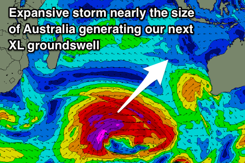
Into Sunday afternoon the forerunners of our new XL long-period SW groundswell should fill in, with the severe and expansive polar low responsible for this swell currently weakening and pushing towards WA (still generating W/SW gales in our swell window).
We saw this low generating a very broad and expansive fetch of severe-gale to storm-force W/SW winds on top an active state, with the scope of the low being almost the size of Australia.
The swell will be a touch under the size of yesterday's swell but with a little more west, so expect very large powerful surf even in protected spots again.
We should see the forerunners arriving overnight Saturday with the swell building strongly Sunday afternoon, reaching at least 8ft by dark, with a peak Monday morning to 12ft+ on the sets across exposed breaks.
An easing trend is likely into the afternoon, dropping back from 8ft to maybe 10ft Tuesday morning.
Winds over the coming days will be moderate to fresh out of the SE, lighter and more variable each morning, with a return to E/SE trades likely later next week.
A new SW groundswell is due later Wednesday and more so Thursday morning next week, produced by a slow moving and slightly unconsolidated but persistent mid-latitude pushing in from south-east of South Africa.
We're looking at 6-8ft sets at the peak of the swell, easing through the end of the week. Following this another 'fun' sized S/SW groundswell is due later the weekend of the 4/5th of August, but more on this Tuesday.
16 day Bali Forecast Graph
16 day East Java Forecast Graph
16 day Sumbawa Forecast Graph
Ments: Similar to Bali, we're see the destructive XXL S/SW groundswell easing across the region, back from the 8ft+ range at magnets tomorrow.
The new swell from the mid-latitude front is expected to keep 6-8ft sets hitting the coast on Saturday, easing temporarily into Sunday morning ahead of the large long-period S/SW groundswell into the afternoon.
This swell will be a touch under what was seen yesterday, though building to an easy 10ft by dark on Sunday ahead of a peak Monday morning to 10-12ft before easing later into the afternoon and more noticeably Tuesday.
The SW swell for Wednesday afternoon looks to keep easy 6ft sets hitting exposed breaks before easing into the end of the week.
Looking at the local winds and persistent fresh and gusty SE-S/SE winds are expected over the coming period as a strong and persistent high pressure ridge sits across the northern Indian Ocean.
This will favour protected breaks away from the brunt of the incoming swells.
16 day Mentawai forecast graph
16 day Nias forecast graph
16 day South Sumatra forecast graph