Fun S/SW swell late week, followed by another good pulse mid-next week

Bali and Mentawais forecast by Craig Brokensha (issued Tuesday 10th October)
Best Days: Every day over the coming period around Bali (slowest Monday and Tuesday), Ments - Friday afternoon and Saturday, Wednesday onwards
This week and next (Oct 11 - 20)
Bali: We've got fun waves out across magnets again today, after an increase in size yesterday. We should see a slightly stronger increase in S/SW swell this afternoon more to the 6ft+ range at magnets before easing back from 5-6ft tomorrow morning, smaller Thursday.
Later in the day Thursday and more so Friday we'll see a new S/SW groundswell building across the region, generated by back to back polar fronts firing up towards WA. While not overly strong we should still see some decent consistent size out of the S/SW, building Friday afternoon and reaching 6ft+ at exposed breaks, easingfrom a similar size Saturday morning.
The swell should continue to ease into Sunday and Monday with our next decent swell due to arrive through Wednesday. Just before this though a distant S/SW groundswell should provide 3-5ft sets Tuesday, produced by a small polar low over the coming days.
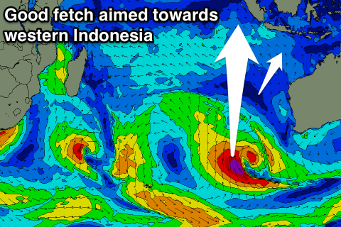 Wednesday's swell will originate from a deepening surface trough, come low), forming west-southwest of WA and projecting a slow moving fetch of gale to severe-gale S/SW winds towards western Indonesia initially and then more towards us.
A moderate-large consistent S/SW groundswell should be seen, arriving Wednesday morning and building to 6ft+ across exposed breaks into the afternoon before easingThursday from a similar size.
Beyond this we may see another good S/SW swell late week, but more on this Thursday.
Fresh E/SE trades should ease back from Friday and become weak from the SE through most of next week (variable early each morning).
16 day Bali Forecast Graph
16 day East Java Forecast Graph
16 day Sumbawa Forecast Graph
Ments: Conditions are currently great across south swell magnets with winds from the north-west and small to moderate levels of background S/SW swell.
We'll see the swell persist tomorrow before easing Thursday. The S/SW groundswell impacting Bali was generated a touch late in our swell window so we'll see smaller surf building through Friday, reaching 5ft on the sets later in the day, easing slowly from a similar size Saturday morning, further Sunday and Monday.
A small lift in S/SW energy is expected later Monday/Tuesday from the small polar low, but only to 3-5ft or so.
Of greater importances is the low aiming the great fetch of S'ly winds towards us this weekend.
We'll see the brunt of the swell with large 6-8ft sets due across exposed breaks when it peaks later Wednesday/Thursday, easing back into Friday.
Winds are due to remain from the N/NW tomorrow, easing into Thursday and then becoming variable over the weekend, taking a slight SE tendency through next week.
16 day Mentawai forecast graph
16 day Nias forecast graph
16 day South Sumatra forecast graph