Fun swell to end the week, large back to back swells next week

Bali and Mentawais forecast by Craig Brokensha (issued Tuesday 8th August)
Best Days: Swell magnets over the coming days and then marquee reefs from Friday
This week and next (Aug 9 - 18)
Bali: A large strong and inconsistent SW groundswell built later Saturday, peaking Sunday morning with great waves on the exposed reefs. It wasn't enough to get the Padang Cup going, with it being generated too far away to retain enough size.
Over the coming days small to moderate amounts of background swell will keep exposed breaks ticking in the 4-5ft range, with a larger S/SW swell due later in the week.
 This swell has been generated by a strong and broad mid-latitude frontal progression, with the final stages of the storm currently pushing up towards North West WA.
We'll see a consistent large S/SW groundswell,building Friday and reaching 8ft across exposed breaks into the afternoon and then easing back slowly through Saturday from a similar size.
E/SE-SE trades pick up later tomorrow and more into Thursday, persisting throughout next week before easing into next weekend. With this light variable winds will be seen early every morning with local land breezes.
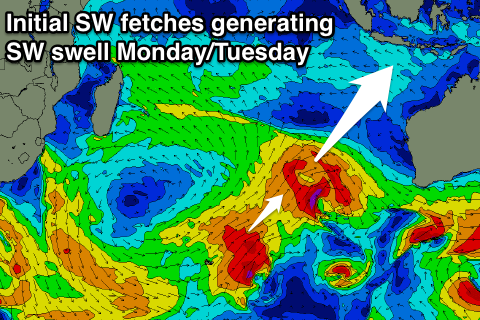
Into next week we're set to see large back to back SW tending S/SW groundswells as a broad and multi-centred mid-latitude low moves in and across the Indian Ocean, projecting flurries of gale to severe-gale winds through our swell window as the broad low stalls west-south-west of WA.
An initial fetch of SW gales, followed closely by a secondary stronger fetch should produce two SW groundswells, the first for Monday afternoon and second for Tuesday afternoon.
 Exposed breaks should build to 6ft+ later in the day Monday, with the secondary larger pulse to 8-10ft due later Tuesday.
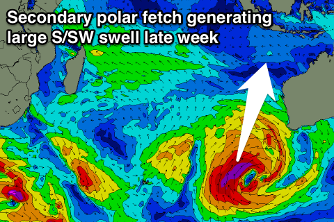
A slight easing trend is then expected Wednesdayahead of a new large S/SW groundswell Thursday from a broad fetch of gale to severe-gale S'ly winds wrapping around the base of the low.
Exposed breaks are due to kick back to 8-10ft, easing through Friday and the rest of the weekend.
We'll have a closer look at all of this on Tuesday.
16 day Bali Forecast Graph
16 day East Java Forecast Graph
16 day Sumbawa Forecast Graph
Ments: After the weekend's swell eased off into yesterday, some new background S/SW energy should be on the build today, coming in around 4-5ft tomorrow morning before easing into the afternoon.
We then look at the S/SW swell due later week, with a touch less size than Bali due across the coast. Exposed breaks are expected to reach 6ft later Thursday with 6ft+ waves Friday, easing Saturday.
Variable winds are due to develop from Thursday (weak SE tomorrow) and remain so through next week.
Next week we'll see large consistent swell across the coast from the broad multi-centred low, but from a S/SW direction early week, more S'th into the end of the week.
Size wise there's not too much difference due across the Ments to Bali earl-mid week, with the S'ly swell coming more in the 8ft range on the sets. More on this Thursday.
16 day Mentawai forecast graph
16 day Nias forecast graph
16 day South Sumatra forecast graph