Easing surf with good SW swells next week

Bali and Mentawais forecast by Craig Brokensha (issued Tuesday 25th April)
Best Days: Both regions every day this week, later Sunday onwards
This week and next (Apr 26 - May 5)
Bali: Large pumping surf yesterday with the arrival of a great S/SW groundswell across the region.
The swell is still strong this morning but should ease this afternoon and further tomorrow, bottoming out Thursday. E/SE trades are expected to kick up a little this afternoon, holding tomorrow (variable early) before easing off again Thursday and remaining lighter for the rest of the period.
A slight bump in inconsistent S/SW swell is expected on Friday, generated on the edge of our southern swell window, south-southwest of WA over the weekend.
This swell should provide inconsistent 4-5ft sets across swell magnets (small on the Bukit) before fading into the afternoon, further Saturday, small Sunday.
Into next week we've got some better aligned SW groundswell energy due across the islands, generated between Madagascar and Heard Island, in the south-west Indian Ocean.
The first swell for Monday has already been generated by a vigorous low producing a fetch of severe-gale to storm-force W/NW winds through our south-western swell window.
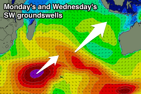 The bulk of the winds were aimed away from us, but the strength of the system will see a moderate to large SW groundswell created.
Long-period fore-runners of this swell are due to arriveSunday, with building sets towards 3-5ft by dark across exposed breaks, filling in further Monday to a peak around 5-6ft+ during the day.
The swell should dip away Tuesday, but a secondary larger SW groundswell is due to fill in later in the day, peaking through Wednesday afternoon.
A better aligned polar front developing under South Africa will generate this swell, projecting an elongated fetch of severe-gale to storm-force SW winds up through the Indian Ocean.
This swell will again be inconsistent but should build to 6ft to occasionally 8ft across swell magnets Wednesday afternoon, easing back slowly from the 6ft range Thursday, smaller Friday.
We may see the trades kick back in late next week, but we'll look at this and further S/SW swell energy for May on Thursday.
16 day Bali Forecast Graph
16 day East Java Forecast Graph
16 day Sumbawa Forecast Graph
Ments: Yesterday's large swell is on the ease across the Mentawai Islands, and will continue to drop through the rest of the week. Exposed breaks to the southerly swell should offer 4-5ft sets tomorrow morning, small Thursday and bottoming out Friday but not below 3ft.
From Sunday the SW groundswell mentioned in the Bali notes will start to kick, reaching a solid 4-6ft by dark Sunday and peaking Monday to 5-6ft+. The secondary larger swell for Tuesday afternoon and more so Wednesday should come in at 6ft to occasionally 8ft during the morning before easing back through the rest of the week.
Weak persistent NW breezes will favour south-east facing breaks over the coming week and weekend, becoming more variable into next week.
16 day Mentawai forecast graph
16 day Nias forecast graph
16 day South Sumatra forecast graph