Slow week ahead of a larger swells from the weekend

Nias, Mentawai, South Sumatra forecast by Craig Brokensha (issued Tuesday 10th May)
Best Days: Thursday and Friday swell magnets, experienced surfers from Saturday afternoon
This week and next (May 11 - 20)
Currently the surf is small across the region with background S'ly and SW groundswell energy stopping swell magnets from going totally flat.
Into Thursday and Friday some small and inconsistent SW groundswell is due, but only in the 4ft range or so across exposed breaks. Variable winds are due through the coming days, with a slight N'ly bias tomorrow and Thursday.
As discussed last update, from Saturday afternoon we'll see some good SW groundswell building across the region, followed by a larger S/SW groundswell Sunday afternoon, peaking Monday.
The first pulse of SW groundswell Saturday is being generated by a small but strong mid-latitude front at the head of a much stronger polar frontal system that's fired up west of Heard Island.
This first front should produce a moderate sized SW groundswell for Sunday, building Saturday to the 5-6ft range across exposed breaks in the Ments, with a secondary pulse Sunday to 6ft+.
The stronger polar frontal system will generate a fetch of gale to severe-gale SW winds through our southern swell window, moving slowly north-east and then east through the southern Indian Ocean.
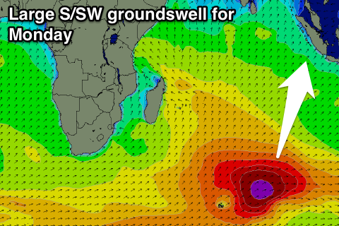 A large prolonged long-period S/SW groundswell will result, building later Sunday but peaking Monday in the 10ft range.
A slow easing trend is then due from 8ft to possibly 10ft Tuesday further down Wednesday and Thursday morning.
A secondary stronger but smaller polar low is forecast to fire up on a slightly more eastern track through Friday evening and the weekend, generating another large long-period S/SW groundswell for later in the week.
This looks to be in the 8ft+ range again, but we'll review this Thursday.
Winds through this period look to remain variable, taking a slight NW bias from Tuesday afternoon through Thursday morning.
16 day Mentawai forecast graph
16 day Nias forecast graph
16 day South Sumatra forecast graph
Comments
Any update coming Craig? Was prob biggest Monday morning, where I'm at,, Tuesday down a bit but still solid and has dropped lots now. Still a few rogues coming through but very inconsistent.
Gday Craig just wondering when the next indo forecast will be published? Cheers mate love your work!
Will have an update on Tuesday, couple of large long period swells on the way!
right on time! thanks craig!
Whats the link there erams ?
Trouble Caml . Don't go there .
Latest update is up.. https://www.swellnet.com/reports/forecaster-notes/mentawai-nias-south-sumatra/2016/05/31/large-swells-week-nw-winds