Good SW groundswell later in the week with limiting winds

Nias, Mentawai, South Sumatra forecast by Craig Brokensha (issued Tuesday 13th October)
Best Days: Protected spots tomorrow and then from later Thursday
This week and next week (Oct 14 - 23)
A fun pulse of SW groundswell this morning should ease back this afternoon and further tomorrow, as poor S/SE winds continue.
Our strong pulse of SW groundswell due into Friday, talked about last update is still on track, with a vigorous and slow moving polar low generating it late last week to the south of South Africa.
A broad fetch of severe-gale W/SW winds were generated through our swell window, with the long-period forerunners expected to arrive through Thursday morning, but with no major size.
Into the afternoon though we should see some good size developing across exposed breaks, reaching an easy 6ft by dark before peaking Friday morning to 6-8ft+ across swell magnets.
From here a slow drop in size is due into Saturday from the 6ft+ range, down further into Sunday and Monday.
Unfortunately fresh S/SE winds are due to persist through the peak of the swell, backing off a touch Saturday before returning Sunday and Monday.
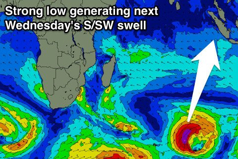 Into next week a fun pulse of S'ly groundswell is due later Tuesday and Wednesday, produced by a strong low forming late in our swell window on Friday. This low will produce an ideally aligned fetch of severe-gale S/SW winds towards us, producing a good S/SW groundswell for Wednesday, peaking around 5-6ft across exposed breaks.
This swell should then drop into Thursday and become smaller Friday as the S/SE winds ease a touch.
Longer term moderate amounts of S/SW groundswell are due across the region from next weekend, but we'll have another look at this on Thursday.
16 day Mentawai forecast graph
16 day Nias forecast graph
16 day South Sumatra forecast graph