Good period ahead, largest early next week

Nias, Mentawai, South Sumatra forecast by Craig Brokensha (issued Thursday 27th August)
Best Days: Every day over the coming period
This week and next week (Aug 28 – Sep 4)
A new S/SW groundswell should fill in this afternoon and peak tomorrow morning to a good but inconsistent 5-6ft+ across exposed breaks around the Ments, holding Saturday morning before tailing off into the afternoon and further Sunday, bottoming out Monday morning.
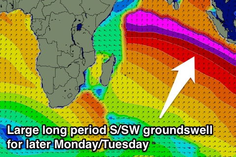 Our large S/SW groundswell due into Monday afternoon and Tuesday morning is still well on track, with satellite observations recording the fetch of 35-60kt winds west of Heard Island. The storm is now weakening slightly and splitting in two, with one of the fronts due to project north-east towards Eastern Indonesia while continuing to generate a fetch of strong to gale-force SW winds.
This will help keep the moderate sized waves in between sets during Monday/Tuesday's swell hitting with size and consistency.
Through Monday we can expect the swell to build rapidly and strongly through the afternoon, reaching an easy 8ft across exposed breaks on dark and then peaking early Tuesday to 8ft to occasionally 10ft, easing into the afternoon and then down from Wednesday through until the weekend.
Winds are due to limit options a little with persistent and moderate to fresh S/SE-SE breezes expected for the entire forecast period.
Longer term the storm track will remain better aimed towards Eastern Indonesia, with moderate plus sized S'ly groundswell energy due to spread up radially into us from Sunday week, with the best pulse likely Tuesday. More on this in the next update though.
16 day Mentawai forecast graph
16 day Nias forecast graph
16 day South Sumatra forecast graph