Slow ahead of better S/SW swell next week but with SE winds

Nias, Mentawai, South Sumatra forecast by Craig Brokensha (issued Thursday 6th August)
Best Days: Exposed breaks until winds freshen from the SE early to mid next week
This week and next week (Aug 7 – 14)
Background levels of SW swell for tomorrow, easing into Saturday and Sunday, bottoming out Monday morning.
Our pulses of S/SW groundswell and S/SE trade-swell are still on track, with the groundswell being generated by a strong polar frontal progression currently well to our south-southwest.
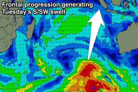 A front will shed off this progression and project north-northeast towards eastern Indonesia, but it will be a little too late in our swell window.
We should still see a slight kick in size and consistency on top of the already fun swell, with exposed breaks in the Ments due to build to the 5-6ft+ range through Tuesday before easing back through Wednesday.
A couple of secondary frontal systems firing up very late in our southern swell window, towards WA on the tail of the main progression should generate two final pulses of S'ly groundswell.
The first arriving later Thursday, providing inconsistent 4-5ft+ sets at exposed breaks, easing back into Friday with a secondary smaller pulse for Saturday.
The S/SE swell from the strong stationary ridge of high pressure to our south has been downgraded a little with it forming a little further south and west, out of our swell window a touch more.
Still we should see exposed spots picking up 3ft+ sets from Monday through Wednesday, easing Thursday.
Winds through next week will increase from the S/SE especially through Tuesday and Wednesday before weakening into Thursday onwards again.
Longer term we may see a funky S'ly swell early the week starting to the 17th, but we'll have to have a closer look at this on Tuesday.
16 day Mentawai forecast graph
16 day Nias forecast graph
16 day South Sumatra forecast graph