Fun southerly swell, slower next week

Nias, Mentawai, South Sumatra forecast by Craig Brokensha (issued Thursday 30th Jul)
Best Days: Exposed spots over the coming period (biggest Friday/Saturday)
This week and next week (Jul 31 – Aug 7)
Make the most of tomorrow's and Saturday's S/SW groundswell as there's nothing too serious on the cards at all for the coming period into early August.
There's been no change to the S/SW groundswell with the Ments due to peak in the 5-6ft+ range Friday afternoon and early Saturday morning.
 Winds will be favourable and tend more variable tomorrow and remain so into next week.
South Sumatra should see sets more in the 6ft+ range, with a touch less size around Nias.
A secondary reinforcing S/SW swell due later Sunday and Monday morning will slow the easing trend but offer no additional size.
Into next week, background levels of SW groundswell will stop the region from going flat, but only offer infrequent 3-5ft surf at best during Thursday/Friday.
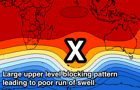
Longer term there's still nothing significant until the week starting the 10th. This will be when an upper level blocking pattern setting up across the Indian Ocean (opposite to strong node of the Long Wave Trough) moves off to the east later next week.
We'll have a closer look at this on Tuesday.
16 day Mentawai forecast graph
16 day Nias forecast graph
16 day South Sumatra forecast graph
Comments
That blocking pattern including the large semi stationary high pressure system at sea level is damn sweet music to anyone heading to the east facing atolls of the Maldives.