Fun swells with light winds

Nias, Mentawai, South Sumatra forecast by Craig Brokensha (issued Tuesday 9th Jun)
Best Days: Every day over the coming period (besides Tuesday morning)
 This week and next week (Jun 10 – Jun 19)
Our recent run of good S/SW groundswell from the weekend has continued into this week and we've got further pulses due over the coming days and weekend.
The weekend's swell was generated by a series of strong cold fronts firing up towards Western Australia last week, and one final system moved through the edge of our swell window later in the week, generating a good S/SW groundswell pulse for later today and tomorrow morning.
This should keep inconsistent 5-6ft sets hitting exposed breaks in the Ments with the odd bigger bomb around South Sumatra tomorrow morning, before easing into the afternoon and further Thursday morning.
The swell shouldn't drop below 3-5ft at exposed breaks though, as a reinforcing and long-range SW groundswell keeps the surf steady through the day Thursday.
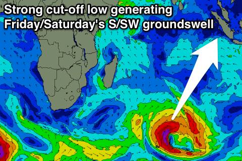
Into Friday and Saturday a good pulse of S/SW groundswell is due, generated by an intense cut-off low in the Indian Ocean the last couple of days. A small but intense fetch of gale to severe-gale SW winds were aimed through our swell window, with an initial pulse due through Friday ahead of a better secondary pulse Saturday morning.
Exposed breaks should see 5-6ft sets through Friday, with the odd bigger bomb a possibility early Saturday morning before the swell eases through the day. Larger surf should be seen around Southern Sumatra, with smaller waves around Nias.
A further drop in size is then due through Sunday and further into Monday.
Conditions over the coming period look generally good at all locations with light variable breezes that may have a slight westerly tendency Wednesday afternoon.
The surf is due to bottom out into Monday evening and Tuesday morning, with some new small background S/SW groundswell energy due through Tuesday afternoon and Wednesday.
A better long-range and very inconsistent S/SW groundswell is on the cards for Thursday afternoon and Friday, but we'll have a closer look at this in the next update.
16 day Mentawai forecast graph
16 day Nias forecast graph
16 day South Sumatra forecast graph