Good swell for the weekend and early next week

Nias, Mentawai, South Sumatra forecast by Craig Brokensha (issued Thu 14th Mayl)
Best Days: Every day over the coming period
This week and next week (May 15 - 22)
A good but inconsistent pulse of SW groundswell this morning should ease back this afternoon and further into tomorrow from 4-5ft across exposed breaks, down to 3-4ft Saturday morning.
An afternoon NW breeze today is expected to become more variable into tomorrow and remain so over the weekend and into next week.
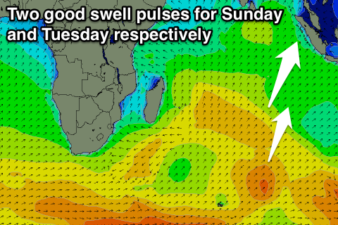
Into Saturday afternoon a good and consistent pulse of S/SW groundswell is due, generated earlier this week by a strong frontal system firing up south-east of South Africa.
The swell should build through Saturday, reaching 4-5ft+ by dark before peaking Saturday to a 6ft+ across exposed breaks during the morning.
A slight drop in size is due through the afternoon and then down further from 5-6ft Monday.
A reinforcing and slightly more southerly S/SW swell is due through Tuesday though, produced by a weakening polar front currently north-east of Heard Island, with this due to keep inconsistent 4-6ft sets hitting exposed breaks Tuesday morning before easing into the afternoon and further through Wednesday.
Into the end of next week a couple of inconsistent S/SW groundswells are due from background polar frontal activity over the coming days, with a late kick Thursday due to hold Friday to 4-5ft+ across exposed breaks.
Beyond this there's nothing too major on the cards for the rest of the month, but we'll review this Tuesday.
16 day Mentawai forecast graph
16 day Nias forecast graph
16 day South Sumatra forecast graph