Easing S'ly swell, fun SW swells from mid-next week

Nias, Mentawai, South Sumatra forecast by Craig Brokensha (issued Thu 7th May)
Best Days: Exposed breaks over the coming period
This week and weekend (May 8 - 10)
Our current strong S'ly groundswell is expected to ease away slowly over the coming days, dropping through the weekend and bottoming out Monday across the region.
Winds are due to be mainly light and variable favouring exposed breaks, picking up the most of the S'ly swell.
 Next week onwards (May 11 onwards)
Early next week there's nothing major on the cards besides very inconsistent and small levels of background SW groundswell.
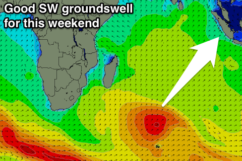
A better but inconsistent SW groundswell is due to build Wednesday and hold into Thursday, with it currently being generated to the south of Madagascar.
Exposed breaks should build to an infrequent 4-6ft Wednesday afternoon and then ease from a similar size Thursday morning.
Winds should remain favourable and mainly light and variable.
A slow drop in size is due through Thursday afternoon and further into Friday and Saturday morning.
A larger SW tending S/SW groundswell is then due into Saturday afternoon and Sunday morning, generated by a stronger polar frontal system firing up south-east of South Africa over the weekend.
A good increase to 6ft to nearly 8ft is due later Saturday before easing from 6-8ft Sunday morning out of a more S/SW direction. From here the swell will slowly tail away with good conditions under light variable breezes.
Beyond this there's nothing to significant on the cards until later in the month, but more on this Tuesday.
16 day Mentawai forecast graph
16 day Nias forecast graph
16 day South Sumatra forecast graph