Slow period with some better southerly swell from Tuesday

Nias, Mentawai, South Sumatra forecast by Craig Brokensha (issued Tue 28th April)
Best Days: Every day over the coming period
 This week and next week (Apr 29 – May 8)
A fun pulse of S'ly groundswell over the weekend has backed off the last couple of days, and will continue to drop through tomorrow, bottoming out into the evening.
From Thursday we'll start to see a touch more swell activity, with some fun and moderate sized S/SW groundswell pulses due ahead of a larger groundswell mid next week.
A slight kick in size from a very inconsistent SW groundswell is due through Thursday, building to an infrequent 3-5ft across exposed breaks.
A better S/SW groundwell is then due to build Friday ahead of a secondary pulse Saturday and third better pulse later Sunday and Monday morning. These S/SW groundswell pulses are being generated by a couple of small frontal systems currently developing to the north-east of the Heard Island region, just within our swell window.
We should see the surf climb slowly to a better but inconsistent 4-5ft through Friday afternoon, holding a similar size through Saturday ahead of the best pulse Sunday, reaching 4-6ft at exposed breaks from lunch time.
A slow drop in size is then due through Monday back from 4-5ft+ further into Tuesday morning.
Winds are expected to be moderate from the NW from Thursday through Saturday before tending more variable into Sunday and early next week.
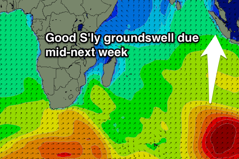
Of greater importance is a strong S'ly roundswell due to build through Tuesday afternoon, peaking Wednesday afternoon across Western Indonesia.
This swell will be generated by a vigorous polar frontal system firing up in the Heard Island region tomorrow, projecting a fetch of gale to severe-gale SW winds up towards WA through the rest of the week, with a secondary intensification over the weekend.
This should produce a pro-longed S'ly groundswell event, arriving through Tuesday morning and then build through the afternoon, reaching 6ft across exposed breaks by dark and then peaking Wednesday afternoon to 6-8ft.
A slow drop in size is then due through Thursday from 6-8ft, further down into the end of the week and weekend.
Winds are looking good and light from the S'th in general, but we'll review this again on Thursday.
16 day Mentawai forecast graph
16 day Nias forecast graph
16 day South Sumatra forecast graph