Very slim pickings until next week

Nias, Mentawai, South Sumatra forecast by Craig Brokensha (issued Tue 25th November)
Best Days: Exposed breaks tomorrow and Thursday morning, then again from Sunday
This week and next week (Nov 26 – Dec 5)
We're on the backside of some good S/SW groundswell across the region but make the most of it as the swell will really bottom out through tomorrow and become near flat through Thursday and Friday.
Winds look favourable for exposed breaks and generally light if not variable from the N'th over the next two days with very weak E/SE trades from Friday through early next week.
Small and very inconsistent levels of background S/SW groundswell energy should boost exposed breaks back to 2ft to occasionally 3ft Sunday with a slightly better pulse Monday to 3ft+ and a touch bigger again increase to 3-4ft Thursday morning around the Ments (5ft bomb sets in South Sumatra).
 These two swells will be from weak polar frontal activity firing up from the Heard Island region towards WA, on the edge of our southern swell window.
Winds from Thursday next week look to increase a touch from the NW unfortunately and persist through until the weekend at least. This will create less than favourable conditions.
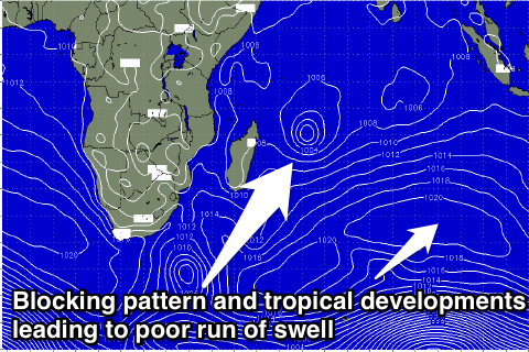
Longer term there's nothing significant at all as a blocking pattern sets up across the Indian Ocean, and we see some tropical developments to our south-west linked to increase tropical activity moving in from the west. More on this Thursday though.
16 day Mentawai forecast graph
16 day Nias forecast graph
16 day South Sumatra forecast graph