The good times continue

Nias, Mentawai, South Sumatra forecast by Craig Brokensha (issued Tue 23rd Sept)
Best Days: Every day over the coming period
This week and weekend (Sep 24 - 28)
After a slower day of surf yesterday, a good new long-range S/SW groundswell has filled in today under favourable winds. This pulse will be reinforced by a secondary slightly more consistent pulse this afternoon and tomorrow morning.
Exposed spots in the Ments should ease from 6ft+ tomorrow morning, with 8ft sets around South Sumatra and a touch less size up at Nias.
Thursday will be smaller again but still in the medium sized plus range at exposed spots in the Ments.
Friday morning is expected to be a low point in activity but a strong long-range S/SW groundswell is due into the afternoon, generated by a deep polar low forming south-east of South Africa on Saturday and projecting a fetch of 40-50kt SW winds towards Eastern Indonesia and then on towards WA.
This swell is expected to build strongly Friday afternoon to an inconsistent but good 6ft+ later in the day in the Ments, and 8ft+ around South Sumatra before easing steadily through Saturday and Sunday. The Ments should see Saturday morning providing the most size to an inconsistent 6ft to possibly 8ft across exposed breaks before backing off through Sunday and further Monday.
Now winds are expected to tend variable around the Ments tomorrow afternoon and possibly from the SW Thursday afternoon before the trades kick in again from Saturday. South Sumatra will see stronger SE trades persisting throughout the period.
Next Monday onwards (Sep 29 onwards)
Monday morning/midday will be another low point in activity, but it will only be temporary with a good consistent S/SW groundswell due to arrive late in the day, peaking Tuesday.
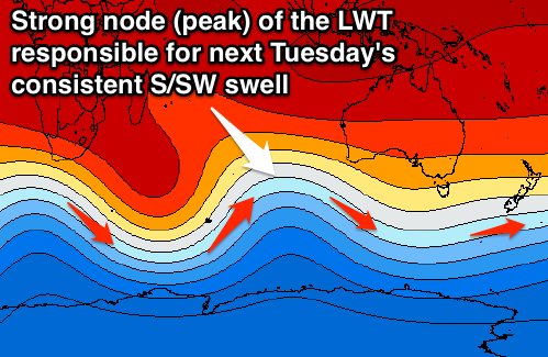 This will be generated by a strong polar front being projected from the Heard Island region up towards Eastern Indonesia again the coming days under the influence of a strong node (peak) of the Long Wave Trough.
With the front pushing up further into the Indian Ocean, the swell will have a lot more consistency than Friday/Saturday's pulse and should come in at 6ft to occasionally 8ft across exposed breaks in the Ments under moderate SE-S'ly winds.
The easing trend through the week will be softened by a series of weaker trailing fronts behind the initial strong system, with winds due to become more variable in the Ments.
Beyond this there's nothing too major on the cards, but we'll review this again Thursday.