Large, long-period and strong S/SW swell Sunday

Nias, Mentawai, South Sumatra forecast by Craig Brokensha (issued Thu 11th Sep)

Best Days: Every day over the coming period for experienced surfers
Tomorrow and the weekend (Sep 12 - 14)
A strong S'ly groundswell arrived later yesterday and peaked this morning across the region with solid waves across exposed breaks. The S'ly direction wasn't ideal though with strong SE trades (weaker around the Ments) limiting options to smaller and protected breaks.
A drop in size will occur into this afternoon and further tomorrow from 6ft+ across exposed spots in the Ments (a bigger 8ft down around South Sumatra) as winds play out similar to the last few days.

A new long-range S/SW groundswell is due on Saturday but this will be just a warm up of what's to come Sunday. Size wise, exposed spots in the Ments should pulse back to an inconsistent 6-8ft into the afternoon, with a touch less size around Nias, while a peak is due Saturday morning around South Sumatra with 8ft+ bombs. Winds should back off a bit in this region but still remain fresh and gusty from the SE.
Now, moving into Sunday, our much discussed, large, long-period and powerful S/SW groundswell is due across Western Indonesia.
We've received some great and frightening satellite passes over the polar storm generating this swell (above right).
A fetch of 50-60kt W/SW winds have been recorded, remaining at strength for nearly 24 hours, with the system now weakening as it pushes towards WA.
A large, long-period S/SW groundswell is now spreading up towards us (with 25s fore-runners arriving Saturday evening) before the bulk of the swell fills in Sunday afternoon.
Exposed spots in the Ments should offer inconsistent 10-12ft sets, while Nias will probably come in the 10ft range, with the odd bigger clean up 15ft bomb due in South Sumatra.
Light to moderate SE winds (fresh and gusty around South Sumatra) will favour slightly protected locations out of the full impact of the swell, but the extra large periods will help the swell wrap in and refract into more protected spots with plenty of size. Therefore it will only be for the most experienced surfer.
Next week onwards (Sep 15 onwards)
A drop in size should be seen through Monday from 10ft+ across exposed spots in the Ments, further down from 6ft+ Tuesday morning.
The next increase in size is due Wednesday afternoon with this being another strong long-period number, but nowhere near the size of Monday morning's swell.
 This will be produced by a secondary polar low firing up further east and being a touch smaller than the system before it, generating a fetch of severe-gale to storm-force W/SW winds through our southern swell window.
The swell should arrive through Wednesday and build to an inconsistent 6ft to possibly 8ft at exposed spots in the Ments late in the day (smaller around Nias and a touch bigger in South Sumatra) before easing into Thursday and the weekend.
SE trades are expected to strengthen a little Tuesday and Wednesday around the Ments, favouring more protected spots with stronger SE winds further south.
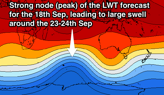
Longer term, another strong amplification of the Long Wave Trough is expected to strengthen through the Southern Indian Ocean around the 17-18th of September, producing a couple of large groundswell pulses for the 23-24th of September. More on this Tuesday though.
16 day Mentawai forecast graph
16 day Nias forecast graph
16 day South Sumatra forecast graph
Comments
Oooohhhhh, I'm getting a little scared looking at that LWT plot for 18th Sept!!!!
Its all good Don. Even if its BIG, it would be good to see and there is the possibility of places that are usually dormant in secluded areas coming alive.
Hope you have a great time. Look forward to a report as it is an area I have wanted to go to.
ECMWF is in line with it as well. Looks to be a matter of size and direction..
Wow where does one get those ECMWF charts from?
Also LoLa has downgraded a fair bit the swell for Sumatra area for this coming Sunday after calibrating their forecasts against actual wind observations
Haha, you'll have to go searching, there's a couple of sources if you look hard enough.
And Weatherzone now have hi-res ECMWF data for corporate clients.
"Haha, you'll have to go searching, there's a couple of sources if you look hard enough."
Gee and I thought we were mates Craig!!! ;)
Ha, don't let a small thing like this ruin that :p Muwhahaha
I think OZCyclone chasers use* a similar tool...
Even for the Indian Ocean?
Not sure aye, that format just looks familiar.
Well perhaps you can resurrect the friendship and provide me with the latest LWT plot for the 18th sept as latest WAMS have downgraded the swell for the following week.
Here's the night of the 18th Don, still good.
Thanks Craig.....friends again!!! ;)
Looks a little less directed at Indo, more so direction at WA?
The node yes, but remember storms are directed just west of where it is positioned. So probably S/SW swells for your region rather than SW.
And I found the site Craig uses above.....I can understand why he's not advertising it!!! :)
haha yeah me too. Didn't take long to figure it out
I really can't see how they're able to offer this data for free (there's a few other websites that do too - check out yr.no). I know how much EC data feeds cost and this product range, at this resolution - globally - is hideously expensive. And usually has tight accompanying restrictions as to the public display of said data. Therefore, make use of it why it's still freely available!
Hahaha yr.no that's actually the first one I checked. I use that to watch continental systems cross into Asia. No advertising either!