Indonesia/Maldives forecast Jul 22

Indian Ocean Basin analysis by Craig Brokensha (issued Tuesday 22nd July)
This week through next (July 21 - Aug 8)
Following large surf late last week, our large reinforcing pulse of S/SW groundswell for Sunday afternoon and Monday morning came in as reported, with the swell easing back further in size today.
The rest of the week looks on the smaller side of the coin, though a moderate sized mid-period S/SW swell is due tomorrow afternoon, generated by a trough that formed off the Western Australian coast Sunday.
This should provide moderate sized surf before easing Thursday, remaining small Friday morning.
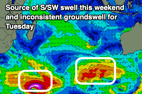
Later in the day Friday a new, inconsistent long-period SW groundswell is expected to start building, with some larger mid-period S/SW energy due into Saturday.
In short the models are incorrectly combining the mid-period energy and groundswell again, over-forecasting the size.
The long-period energy was generated by a strong but short-lived and tight polar low that formed south-east of the Heard Island region over the weekend, with follow up fetches of W/SW gales adding to the swell.
This by itself only looks to generate moderate + sized surf into later Friday and Saturday, but a healthy polar front projecting up towards Western Australia today and tomorrow while weakening will generate some larger, more consistent mid-period S/SW swell.
Size wise Bali looks to see 6-8ft waves across exposed breaks Saturday, easing Sunday, smaller Monday.
Come Tuesday, another long-period S/SW groundswell is due though only moderate + in size, generated by another strong, tight but distant polar low forming south-east of South Africa.
This may be backed up by some reinforcing mid-period S/SW swell with a touch more size Wednesday but we’ll have to review this Thursday.
Longer term we should see a stronger, northward protruding cold outbreak through next week, generating some larger groundswell from next weekend.
The current, weak E/SE-SE trades are expected to persist over the coming days, shifting more SE from Friday while freshening, E/SE on the weekend and then fresh to strong SE early-mid next week.
The coming swells for the Mentawais aren’t as ideal, coming in more south and with a touch less size while a significant fetch of SE trades setting up south of us next week will generate some moderate sized S/SE swell for next week.
Local winds look generally variable this week and SE across southern locations with these winds expected to freshen a little through the weekend and into next week, becoming strong at times. To the north weaker, more variable winds are due.
----------------------------------------------
Maldives:
A good pulse of SE trade-swell was seen over the weekend, with it since easing into the start of the week, further today.

We should see the new pulse of S/SE groundswell filling in tomorrow, generated by tight mid-latitude low on the weekend to the north of the Heard Island region. This looks to offer the most size with the super-charged S/SE trade-swell due tomorrow unfortunately being downgraded to stock standard trade-energy. It also looks to be a bit more S’th in direction owing to the fetch linked to it not expected to form as forecast last week.
We’re still expecting moderate + sized waves, persisting into the end of the week, while from later Sunday through next week, we’ve got larger surf due as a much more significant fetch of E/SE-SE trades is expected to develop south-west of Java.
At this stage the swell looks solid out of the S/SE tending SE through early-mid next week but more on this Thursday.
Winds have backed off a touch across northern and central locations from the W and they’ll continue to ease into the weekend while tending more SW. Southern locations are expected to see freshening S/SE winds over the coming days, strong through the weekend before easing into Monday.
Eastern Indonesia:
Moderate sized mid-period S/SW swell tomorrow afternoon and Thursday morning to 4-5ft+ across exposed breaks.
Moderate + sized, inconsistent S/SW groundswell building later Friday, peaking Saturday mixed in with a larger mid-period S/SW swell to 6-8ft. Swell easing Sunday.
Moderate + sized, inconsistent S/SW groundswell to 4-6ft across exposed breaks Tuesday.
Larger swell on the cards for next weekend.
Weak E/SE-SE trades over the coming days, shifting more SE from Friday while freshening, E/SE on the weekend and then fresh to strong SE early-mid next week.
Light, local offshore winds are due each morning.
Uluwatu 16-day Forecast Graph/WAMs
Western Indonesia/Mentawais/South Sumatra:
Moderate sized mid-period S’ly swell tomorrow afternoon and Thursday morning to 5ft across exposed breaks.
Moderate + sized, inconsistent S/SW groundswell building Friday, peaking Saturday to 6ft to occasionally 8ft across exposed breaks, easing Sunday.
Moderate sized, inconsistent S/SW groundswell for Tuesday to 4-5ft+.
Moderate sized S/SE trade-swell for early-mid next week.
Larger swell on the cards for next weekend.
Generally variable winds this week, tending SE across southern locations with winds expected to freshen a little through the weekend and into next week, becoming strong at times.
Mentawai 16-day Forecast Graph/WAMs
Maldives:
Mix of moderate + sized S/SE groundswell and S’ly trade-swell building tomorrow to 4-5ft+ across the southern atolls (smaller Male).
Swell easing a touch through Thursday to 4ft+ across the southern atolls, increasing again from Friday.
Larger S/SE tending SE trade-swell developing from later Sunday through early-mid next week to 6ft+ across the southern atolls (smaller Male).
Easing W’ly winds this week across the northern and central atolls, weaker SW into the weekend. Southern locations are expected to see freshening S/SE winds over the coming days, strong through the weekend before easing into Monday.
Comments
Latest notes are live.
Thanks O’s
Woohoo! Currently packing for a Sunday arrival in G Land.
Sounding like a solid week of swell, without being too crazy.
Thanks Craig!