Indonesia/Maldives forecast May 27

Indian Ocean Basin analysis by Craig Brokensha (issued Tuesday 27th May)
This week through next (May 28 - Jun 6)
Following the larger swells late last week and into the weekend, we’ve got a slow downwards trend in activity, slowed by a reinforcing pulse of mid-period S/SW swell across eastern locations today.
The surf will continue to back off through tomorrow, with a flukey pulse of S-S/SE groundswell due across the Java region on dark tomorrow if not Thursday morning. The source of this flukey swell was a strong polar front projecting up towards Western Australia during the weekend, producing fetches of strong to gale-force S’ly winds and the large surf seen across the South West yesterday morning.
Moderate sized sets may be seen with smaller surf from about Bali, east.
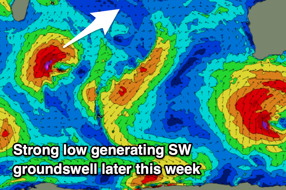
We then look at the inconsistent SW groundswell energy due later week, generated by some distant storm activity south of South Africa, followed by a more robust and tight mid-latitude low that formed south-east of Madagascar.
This low has done the bulk of the swell production, with a tight fetch of gale to severe-gale W/SW-SW winds generating a moderate + sized pulse of inconsistent SW groundswell that should build Thursday afternoon, peaking through Friday across the Bali region. The swell will be in earlier across the Mentawai and a little bigger, strong later Thursday, peaking Friday.
Now, the secondary re-intensification of the low to the south-west of Indonesia should generate some reinforcing mid-period SW swell for Saturday, though not likely above Friday’s energy.

Moving into early next week, another inconsistent, moderate sized SW groundswell is due Monday, with it generated by another distant storm, that being a polar low that formed south of South Africa Sunday. A tight fetch of severe-gale to storm-force W/NW winds were generated, with then low since weakening while moving east yesterday and today.
The size of this swell looks to be under that seen later this week and Saturday, with the models incorrectly combining the energy easing into Monday with the long-period swell train, but it looks to be a quality groundswell at that.
Otherwise we’re looking at a stronger and larger S/SW groundswell mid-week, generated by a strong mid-latitude low forming west of Western Australia this weekend. With core wind speeds near storm-force it should generate a good, consistent and large swell for Wednesday that will have longevity, tending more south while easing later in the week. More on this Thursday.

Our current variable, local winds will remain so into Thursday before freshening E/SE trades kick in from Friday, persisting into next week.
In the Mentawais winds will become variable across all locations tomorrow with SE winds kicking in across southern locations from Friday, persisting through until Sunday before going variable again.
----------------------------------------------
Maldives:
The weekend’s SE trade-swell is now on the ease and will continue to slowly fade throughout the week, with the next pulse of energy due out of the S’ly on Saturday.
This will be thanks to an intensification of SE trades south of region yesterday and today, with a moderate sized swell due to build later Friday, peaking Saturday to 4-5ft+ across the southern atolls with 4ft set across central locations.
The trades will temporarily weaken before increasing again to our south over the weekend, generating some new, moderate + sized S/SE energy for most of next week. We’ll confirm this Thursday.
Now, looking at the groundswell from the low off Madagascar and that’s due to kick later today ahead of peak tomorrow with no change to the expected size. Southern atolls will be large but with S’ly winds.
As touched on, the strengthening S’ly trades will then produce some decent S’ly swell for the weekend, then S/SE next week.
The strong low forming west of Western Australia should generate a large S'ly groundswell for later next week as well, but we'll review this Thursday.
Local winds are an issue this period and strong from the W/SW-SW across northern and central locations, a touch weaker but still fresh and S’ly across southern locations. These winds might back off into next week that’s yet to be seen.
Eastern Indonesia:
Flukey, moderate sized S’ly groundswell for Java later tomorrow but more so Thursday.
Moderate + sized, inconsistent SW groundswell building later Thursday, peaking Friday to an inconsistent 6ft across exposed breaks.
Reinforcing S/SW swell to a similar size on Saturday, easing Sunday.
Inconsistent, moderate sized SW groundswell Monday to 4-6ft across exposed breaks, easing Tuesday.
Larger S/SW groundswell likely Wednesday to 8ft across exposed breaks, easing slowly into the end of the week.
Variable winds (local offshore each morning), with fresh E/SE trades kicking in from Friday (variable offshore each morning).
Uluwatu 16-day Forecast Graph/WAMs
Western Indonesia/Mentawais/South Sumatra:
Large SW groundswell building Thursday, peaking Friday to 6-8ft across exposed breaks, easing slowly into the weekend.
Moderate + sized, inconsistent SW groundswell for Monday to the 6ft range across exposed breaks.
Large S/SW groundswell for later Tuesday/Wednesday to 8ft.
Variable winds tomorrow, with SE breezes kicking in across southern locations from Friday through Sunday, variable next week
Mentawai 16-day Forecast Graph/WAMs
Maldives:
Slowly easing SE trade-swell this week.
Large S/SW groundswell building later today, peaking tomorrow to 6ft to occasionally 8ft across the southern atolls (smaller Male).
Moderate + sized S’ly swell Saturday to 4-5ft+, easing Sunday
Moderate + sized mid-period S/SE swell for next week to 4-6ft across southern and central locations.
Fresh SW winds tomorrow and then more S’ly across the southern atolls through the weekend (holding fresh SW in the north Saturday, S/SW Sunday).
Fresh to strong W/SW-SW winds across northern and central locations, weaker but still fresh S’ly to the south. Easing winds into next week.
Comments
Latest notes are live, lots to digest.
Thanks Craig, first couple of weeks in June looking good.