Indonesia/Maldives forecast May 22

Indian Ocean Basin analysis by Craig Brokensha (issued Thursday 22nd May)
This week through next (May 23 - 30)
The surf is on the build today across the regions thanks to a mix of new SW groundswell and later arriving S/SW energy, emanating off a strong frontal system that moved through the Indian Ocean from Friday through until Monday this week.
The earlier stages south-east of South Africa have generated the SW component which is building today, while the secondary intensification right off Western Australia should be generating some additional S/SW energy later today and tomorrow morning.
We then have the large, long-period spike of groundswell due later tomorrow across eastern Indonesian and southern parts of western Indonesia.
This swell pulsed strongly with its arrival across Western Australia into mid-late yesterday afternoon and with the arrival slated for the afternoon and more so evening Friday, we could see it peaking overnight. This peak would likely reveal 10ft sets on the magnets across eastern Indonesia, but timing wise we may only see 8ft sets on dark tomorrow and Saturday morning before easing.
We can expect the swell to continue easing into Sunday morning, but through the afternoon and Monday morning, a reinforcing pulse of mid-period S/SW swell is due, produced by a broad but relatively weak frontal system currently projecting up and into Western Australia.
This should maintain 6ft sets across the magnets Monday morning before then easing Tuesday and Wednesday, bottoming out Thursday.
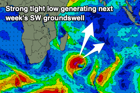
From Friday into next weekend and early the following week we’ve got a good run of SW groundswell on the cards, with a mix of long-range and inconsistent energy from the south of South Africa, and then some more consistent, bigger and closer-range swell from a low forming south-east of Madagascar.
The low will actually spawn off the back of the frontal activity to the south and south-east of South Africa, with a great, small fetch of severe-gales due to project east-northeast then east through the Indian Ocean, producing a moderate to large sized SW groundswell.
The long-range energy and closer-range stuff look to arrive around the same time Friday in eastern Indonesia, earlier and Thursday across locations to the west, with a peak due later Friday/Saturday across Bali and Friday in the Mentawais.
We’ll confirm this next week.
Looking at the local winds, we’re still expecting the trades across eastern Indonesia to weaken into the weekend, tending more variable N’ly Sunday and then NW early next week as a tropical depression forms south of the region. Winds should go more variable again mid-week with trades kicking in again from later week.
In the Mentawais, a small disturbance today across southern locations should weaken, bringing more variable winds tomorrow, remaining so Saturday with weak N/NW winds developing Sunday, a little fresher Monday. These winds will slowly ease through next week before becoming variable from about Wednesday afternoon/Thursday.
----------------------------------------------
Maldives:
In the Maldives we’re seeing easing levels of S/SE swell that should be reinforced by some new SE trade-swell energy later Friday and into Saturday, generated by a healthy fetch of E/SE-SE trades south of Indonesia the past couple of days.
This fetch is projecting slowly west while weakening, maintaining some decent size into Sunday morning before easing slowly through next week.
It looks like we’ll see the trade-flow re-establish to our south through next week and this should lead to a renewal of S-S/SE trade energy later next week/weekend but we’ll look at this closer Tuesday.
Otherwise, the S/SW groundswell from yesterday is slowly easing but a reinforcing pulse from the backside of the ‘bombing’ low should arrive through tomorrow, peaking through the day then slowly easing into the weekend. A moderate sized mid-period S/SW swell will slow this trend on Saturday afternoon/Sunday ahead of our stronger swell next week.
This large S/SW groundswell that’s due to arrive later Tuesday but peak Wednesday will be generated by the low forming south of Madagascar Saturday, with the fetch of severe-gale winds due to produce a large, consistent S/SW swell that looks to have some longevity thanks to the slow, eastward projection of the low.
Looking at the winds and the current westerly flow is due to shift SW tomorrow and then more S’ly across the southern atolls through the weekend (more SW in the north Saturday, S/SW Sunday).
Fresh SW winds then look to persist across northern and central locations next week, weaker and more S/SE to the south.
Eastern Indonesia:
Moderate + sized S/SW groundswell building today to 6ft+, across exposed breaks, similar Friday morning.
Larger, less consistent but strong S/SW groundswell for later Friday afternoon to 8ft, easing from a similar size Saturday morning.
Slowly easing surf from Sunday through next week, with a reinforcing pulse maintaining 6ft sets Monday morning.
Mod-large, inconsistent SW groundswell building Friday, peaking later and Saturday morning to 6ft+ across exposed breaks.
Weakening trades over the coming days variable from from the N Sunday and NW into early-mid next week. Variable winds mid-week with trades kicking in again from later week.
Uluwatu 16-day Forecast Graph/WAMs
Western Indonesia/Mentawais/South Sumatra:
Moderate + sized S/SW groundswell building today to 6ft+, across exposed breaks later, similar Friday.
Larger, less consistent but strong S/SW groundswell for very late Friday in the south to 6ft+, easing from a similar size Saturday morning.
Easing surf from Sunday into next week.
Large SW groundswell building Thursday, peaking Friday to 6-8ft across exposed breaks, easing slowly into the weekend.
Variable winds tomorrow, remaining so Saturday with weak N/NW winds developing Sunday, a little fresher Monday. Easing winds next week before becoming variable from about Wednesday afternoon/Thursday.
Mentawai 16-day Forecast Graph/WAMs
Maldives:
Easing S/SE trade-swell today and into tomorrow morning, with a reinforcing pulse of SE trade-swell later Friday and Saturday to 4ft across Male. Slowly easing SE swell Sunday into next week.
Moderate sized S/SW groundswell Friday to 4ft+ across the southern atolls, easing into the weekend.
Moderate sized mid-period S/SW swell building Saturday, reaching 4ft+ across the southern atolls later, easing from a similar size Sunday.
Large S/SW groundswell building later Tuesday, peaking Wednesday to 6ft+ across the southern atolls.
Fresh SW winds tomorrow and then more S’ly across the southern atolls through the weekend (holding fresh SW in the north Saturday, S/SW Sunday).
Fresh SW winds across northern and central locations next week, weaker and more S/SE to the south.
Comments
Latest notes are live.
Thanks Craig , looks like swell for a few weeks. Crowds have increased, plenty of families taking their kids out of school for a few weeks and the learn to surf schools are doing a roaring trade . Seems like the whole world is learning to surf .