Indonesia/Maldives forecast May 20

Indian Ocean Basin analysis by Craig Brokensha (issued Tuesday 20th May)
This week through next (May 21 - 30)
The swell is bottoming out across the region and we’re expecting it to stay small tomorrow.
Into Thursday, an inconsistent S/SW groundswell is due to fill in, building slowly through the day ahead of a peak later, generated by a flurry of decent Southern Ocean storm activity to the far west and then south-west of Western Australia over the weekend and into yesterday.
A good mid-latitude frontal system linked to the large offshore surf in Margaret River today should fill in through the day, building towards a peak later, holding Friday morning. It looks moderate + in size across the magnets and will be more than welcomed after the recent small run of waves.
Later in the day Friday a stronger but less consistent S/SW groundswell is due to arrive, peaking overnight before easing Saturday.
The source is a ‘bombing’ low that formed east of the Heard Island yesterday, with pre-frontal, severe-gale NW winds being aimed away from us, while a better but tight fetch of storm to hurricane-force W’ly winds were generated late in our southern swell window.
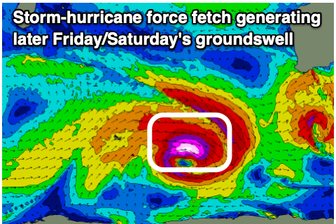
The easterly track and westerly aimed fetch aren’t ideal, but the strength of the low can’t be ignored and with this we should see a larger, inconsistent S/SW groundswell building into the afternoon with 8ft sets later across exposed breaks (possible rare bigger ones true magnets), easing from a similar size Saturday morning.
The trend will then be down from Saturday afternoon through Sunday and early next week, slowed only slightly by some reinforcing mid-period S/SW swell from a weak frontal system projecting towards Western Australia tomorrow.
Longer term, there’s nothing too major on the cards until possibly next weekend, but more on this Thursday.
Looking at the local winds and our current strong trades will ease off slowly this week, just holding in through the weekend before then going variable early next week and even possibly W’ly mid-week as a tropical depression deepens south of us.
Over in the Mentawais and the swells for the coming days will be a touch smaller and more south in direction, favouring selected spots while being inconsistent.
The long-period S’ly groundswell isn’t really due until very late Friday, with Saturday seeing the most energy. Local variable winds are due to start increasing from the NW from the weekend, favouring those south magnets.
----------------------------------------------
Maldives:
A strong pulse of S/SE trade-swell should be building across the Maldives today, with a peak due through tomorrow, generated by a great fetch of E/SE trades that are now easing and slowly moving more east.

The swell looks moderate + in size, easing off slowly through the end of the week and weekend, thanks to the persistent fetch of E’ly winds south of Java over the coming days.
Across the southern atolls a new S/SW groundswell is due to build later today, peaking through tomorrow before easing Thursday, smaller Friday. The easing trend will be slowed by a smaller reinforcing S’ly groundswell generated by the ‘bombing’ low but I don’t like the potential from this system with it forming a little too far east.
The weekend looks a bit more active with a new, moderate sized pulse of mid-period S/SW swell due, but of greater significance is a larger S/SW groundswell for mid-next week, generated by a tropical low forming south-east of Madagascar this weekend.
We could see this low projecting a great fetch of S/SW gales towards us, with large surf due next Wednesday, but more on this Thursday.
Eastern Indonesia:
Moderate + sized S/SW groundswell building Thursday to 6ft+, across exposed breaks, coming in more 6ft Friday morning.
Larger, less consistent but strong S/SW groundswell for Friday afternoon to 8ft (possible rare bigger ones true magnets), easing from a similar size Saturday morning.
Slowly easing surf from Sunday through next week.
Strong E/SE-SE trades over the coming days (variable each morning). Weakening trades from Friday, variable from Sunday and NW into early-mid next week.
Uluwatu 16-day Forecast Graph/WAMs
Western Indonesia/Mentawais/South Sumatra:
Moderate + sized S/SW groundswell building Thursday to 6ft+, across exposed breaks later, similar Friday.
Larger, less consistent but strong S/SW groundswell for very late Friday in the south to 6ft+, easing from a similar size Saturday morning.
Easing surf from Sunday into next week.
Variable winds, increasing a little from the NW early-mid next week.
Mentawai 16-day Forecast Graph/WAMs
Maldives:
Moderate + sized S/SE trade-swell building this afternoon, peaking tomorrow to 5-6ft across the central and southern atolls. Slowly easing swell from Thursday through the weekend.
Slightly smaller S/SW groundswell in the mix later today and tomorrow across the southern atolls, easing slowly into the end of the week.
Moderate sized mid-period S/SW swell building Saturday, reaching 4ft+ across the southern atolls, easing from a similar size Sunday.
Easing S/SW swell early next week.
Large S/SW groundswell building later Tuesday, peaking Wednesday to 6ft+ across the southern atolls.
Strong W/SW winds, easing slowly this week (weaker and more SW to the south).
Winds tending S/SW from the weekend and strengthening (weaker to the south).
Comments
Latest notes are live.
Thank you Craig , been a few waves lately but inconsistent, today is tiny on NL but looking forward to the weekend coming up .
Nice one Craig. Opportunity has arisen to do a strike mission next week with wife and bub. I was pushing to go Supa's way for a more relaxed vibe but wife is all over the family friendly resorts on the western side of the bukit. Sounds like it could be an okay week for the traditional wet season spots?
Yeah could be.