Indonesia/Maldives forecast January 11

Indian Ocean Basin analysis by Craig Brokensha (issued Thursday 11th January)
This week through next (Jan 12 - 19)
A slow easing trend in surf should be seen across the Indonesian archipelago, more noticeable to the west, as some reinforcing energy softening the trend was generated to the south-west of Western Australia, more aimed into eastern regions.
A final pulse of reinforcing S/SW swell that’s come in nicely across Western Australia today should arrive later tomorrow ahead of a peak Saturday morning. It should offer fun sets on the exposed breaks before easing into Sunday and early next week.
The swell was generated by persistent fetches of strong W/SW winds to the south-west of Western Australia linked to favourable frontal activity.
One final fetch of stronger but slimmer polar gales are due to generate an inconsistent S/SW groundswell for Tuesday. The models are overcooking the size a little though so expect a touch under the size of Friday/Saturday morning’s pulse but with a little more push. It’ll be very inconsistent though.
Winds are due to strengthen a little over the coming days out of the W/SW-SW into the afternoon’s, W/NW in the mornings. These winds look to continue but in a weaker form next week.
In western Indonesia, current NW winds are due to ease tomorrow and swing E/SE on Saturday then more variable Sunday before a stronger NW monsoonal flow develops next week (Tuesday onwards).
Over in the Maldives, strong monsoon winds have extended to the atolls adding lots of local, stormy windswell to the mix that’s in the 4ft range.
These winds will persist tomorrow and into the weekend, slowly breaking down through next week so until then there’ll be the winds and swell to contend with.
Across the southern atolls winds are due to shift S/SW temporarily tomorrow, more variable Saturday then back to the N/NE on Sunday.
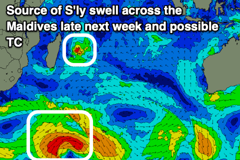
Looking at other swell sources and this week’s good S’ly groundswell is now easing and will continue to do so into the weekend.
A cyclone forming off Madagascar looks tricky swell wise, with a more reliable S’ly groundswell possible late next week. More on this next Tuesday.
Eastern Indonesia:
Late pulse of moderate sized, mid-period S/SW swell tomorrow to 4-5ft, easing from a similar size Saturday morning.
Smaller, inconsistent S/SW groundswell for Tuesday to 4ft on the magnets, easing into the end of the week.
Morning W/NW winds, fresher W/SW-SW into the afternoons, easing in strength through next week again.
Uluwatu 16-day Forecast Graph/WAMs
Western Indonesia/Mentawais/South Sumatra:
Easing swell later week and further into the weekend.
Small, inconsistent S/SW groundswell building Monday to 3-4ft across the south magnets, easing Tuesday.
Current NW winds are due to ease tomorrow and swing E/SE on Saturday then more variable Sunday before a stronger NW monsoonal flow develops next week (Tuesday onwards).
Mentawai 16-day Forecast Graph/WAMs
Maldives:
Stormy E/NE windswell to 4ft across northern regions today and tomorrow, easing slowly next week.
Easing S’ly groundswell into the end of the week and weekend.
Possible fun S’ly groundswell for late next week.
Strong E/NE-E winds across northern and southern locations, tending NE next week.
Across the southern atolls winds are due to shift S/SW temporarily tomorrow, more variable Saturday then back to the N/NE on Sunday.
Comments
Latest notes are live.
Thanks Craig
DP
I am calling swell of the season heading to PNG for 20 January onwards. Backup swells coming behind it Anyone left who is not currently in Japan buried in Japow - get you ass to PNG !
(2m - 3m @12 -15 seconds, Due North swell arriving in Vanimo at dawn on 20th, building through the day at Kavieng and New Ireland. Peaking 21st with a long tail.
Yeah, a lot of places in that part of the world going to be lighting up.
Will be interesting to see what happens at pp.
PNG forecast gets an upgrade. Swell building on 20th and 21st (2.2m @12 sec) - peaking on 22nd January - currently forecast to exceed 3m @16 seconds. This could be one of the most significant swells to hit PNG in years. And it has a long tail with another swell due towards end of the month