XL swell for tomorrow, though with poor winds, fun swells next week

Hawaii North Shore, Micronesia and PNG forecast by Craig Brokensha (issued on Tuesday 18th December)
Best Days: North Shore - later Wednesday and Thursday, then late Monday onwards next week, Micronesia - Wednesday, early Thursday, Monday afternoon onwards, PNG - every day
This week and next (Dec 14 - 21)
Hawaii: We've seen pumping waves for the last two days across the North Shore with the Pipeline Masters finishing with a bang.
 While the swell is on the ease, a very temporary low point is expected early tomorrow ahead of a new XL N/NW groundswell building through the day, peaking into the evening.
This has and is still being generated by a secondary vigorous low forming on the back of an initial storm that generated Sunday's swell.
We've seen a great fetch of severe-gale to storm-force W/NW winds generated through our northern swell window, with building surf to 12-15ft expected later tomorrow (a touch less than forecast last week), easing back from 10-12ft+ Wednesday morning, smaller and from the 8ft range on the sets Thursday.
Winds are still an issue, with an early light E/NE offshore due to strengthen from the N/NE through the day, remaining strong from the NE Wednesday and swinging back to the E/NE on Thursday and remaining gusty.
Friday will be nice and clean but back to the small 3-4ft range.
Unfortunately there's nothing too significant due into the weekend, with our next swell arriving from the NW later Monday and being quite a prolonged event.
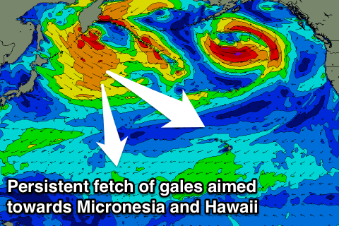 This swell event will be generated by a flurry of storms developing off Japan, with a broad and persistent fetch of strong to gale-force W/NW winds due to be directed through our long-range swell window, ahead of a final storm projecting towards us later in the weekend.
We should see inconsistent levels of NW groundswell, arriving later Monday and building to 4-5ft by dark and peaking Tuesday to 5-6ft. A slightly stronger swell is due off the projection towards us, arriving Wednesday morning and providing better 8ft sets before easing into the afternoon, smaller Thursday. Winds through this period look great with moderate to fresh E'ly trades, but more on this Thursday.
North Shore Forecast Graph
North Shore WAMs
Micronesia: We've got small levels of E/NE trade-swell on the build across the region, but a small pulse of N'ly groundswell is due from the secondary low moving through the North Pacific, with it filling in tomorrow.
Reef passes open to the north should see inconsistent 3ft+ sets with gusty E/SE trades, easing back slowly through Thursday.
There isn't anything significant to follow until next week, when we see the storms off Japan generating small pulse of N/NW groundswell from Monday through Friday.
The first pulse for Monday should build to 3-5ft, easing back slightly from a similar size Tuesday, with a secondary pulse Thursday back to 4-5ft or so. Gusty E/NE trades are due to kick back in through the week, favouring these northerly friendly reef passes.
Palikir Pass Forecast Graph
Palikir Pass WAMs
Papua New Guinea: No real change from last week's notes, with persistent fun levels of NE trade-swell due across the exposed reefs to the north-east over the coming fortnight, easing back a little through next week.
This will be a result of a fetch of broad persistent E/NE trades weakening into the weekend and early next week. Size wise, we should see surf around 3ft+ through until early next week, easing back slowly towards 2ft to occasionally 3ft late week. Winds look generally favourable until increasing from the NW mid-late week which isn't too favourable.