Easing surf with raw N/NW swell building Sunday, XL swells to follow

Hawaii North Shore forecast by Craig Brokensha (issued Thursday 4th February)
Best Days: Thursday, Friday, Monday onwards for experienced surfers
This week and next (Jan 29 – Feb 5)
Monday's epic day of waves for the Volcom Pipe Pro continued into Tuesday but with less size through the morning before a new pulse of large N/NW groundswell kicked through the afternoon and evening.
This swell has dropped back slowly through today and will continue to ease through off into tomorrow, with nothing significant due through Friday and Saturday.
Our mix of mid-period N/NW swells due into Sunday are still on track, but there'll be some longer-period and stronger energy in the mix now.
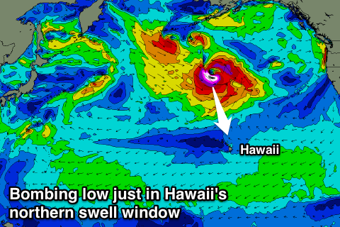 A deepening low pressure system to our north-northwest on Friday will 'bomb' dropping from 1000hPa down to 960hPa in 24 hours, a lot more than the requited 24hPa in 24 hours.
This will result in a broadening and strengthening fetch of severe-gale to storm-force NW winds being generated right on the edge of our northern swell window (right), producing a large pulse of N/NW groundswell for Sunday afternoon.
Before this arrives through, a front shedding off the back of the 'bombing low' will project a fetch of strong to gale-force N/NW winds right into the Islands on Saturday evening, producing a short-range N/NW swell for the morning.
Size wise we should see junky and raw 8-10ft surf, building through the day, mixing in with the stronger long-period N/NW groundswell and reaching the 15ft range later in the day.
Both swells are then due to peak overnight and ease back through Monday from 12-15ft, back down more steadily from 8-10ft Tuesday morning.
Conditions through Sunday will be poor as the front pushes into the Islands resulting in strong but easing N/NW tending N'ly winds, while Monday should be much better as winds tend more variable. Funky and light to moderate W'ly winds are due Tuesday before swinging back to the N/NE Wednesday.
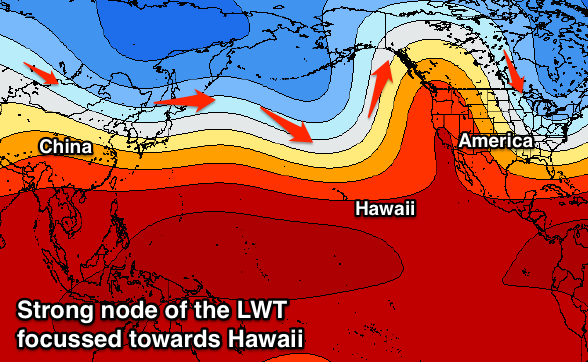 From Wednesday through until next weekend, we've got a series of XL if not XXL swells due to impact the islands as a strong node (peak) of the Long Wave Trough strengthens across the central North Pacific.
This should project a series of vigorous storms towards Hawaii through most of next week, with an initial XL swell Wednesday/Thursday likely to be followed by another Saturday/Sunday. We'll have a closer look at this on Tuesday though.