Fun, easing E/NE swell followed by S'th

Eastern Tasmanian Forecast by Craig Brokensha (issued Monday May 26th)
Best Days: Keen surfers Friday, beaches Saturday morning, keen surfers Tuesday and Wednesday mornings
Features of the Forecast (tl;dr)
- Mix of easing E/NE swell and N/NE windswell tomorrow with W/NW tending strong S/SW winds
- Mod-large building S swell Wed with strong SW tending S/SW winds
- Easing S swell Thu with W/NW tending E winds
- Possible moderate sized S'ly groundswell building later Fri, eaing Sat with W/NW tending NE winds
Recap
A large, consistent E/NE groundswell filled in on Saturday though north winds limited the best waves to northern ends, with yesterday coming in a bit more manageable across all locations with better offshore winds.
Today the swell was down a bit further though strengthening north winds are again favouring northern ends.
This week and weekend (May 27 - Jun 1)
Tomorrow looks much cleaner with more options across the coast as an approaching mid-latitude low brings fresh W/NW tending stronger S/SW winds.
A good mix of background E/NE swell from the deepening trough over the weekend and local N/NE windswell should come in at 3ft to occasionally 4ft, smaller into Wednesday.
We then look to our south with the remnants of the strong mid-latitude low moving in and across us due to deepen east of us, projecting a fetch of strong S/SW winds up our coast tomorrow evening.
The formation of a broad Tasman Low will see strong, expanding S/SW winds into Wednesday before projecting north into the northern Tasman Sea during the evening.
This will produce building levels of mid-period S’ly swell for Wednesday, likely peaking through the day to 6ft+ across the south facing beaches with smaller waves in more protected spots. Strong SW-S/SW winds will limit options to these southern corners which will be small, with a better W-W/NW offshore due on Thursday with easing sets from 4-5ft on the south magnets, smaller elsewhere.
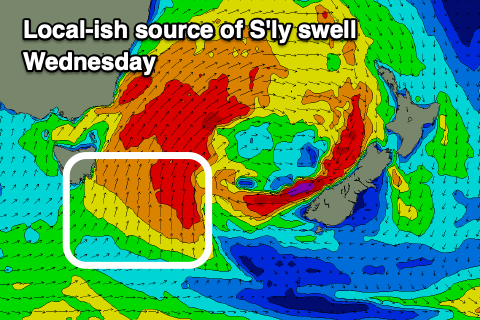
Following this solid local increase in S’ly swell, we’re due to see some solid, moderate sized S’ly groundswell into later Friday and Saturday morning.
The source will be a strengthening polar frontal progression south of the state later week and we could see 4-6ft sets on the south magnets when it peaks later Friday and into Saturday morning.
The models diverge a little on the strength of this polar frontal system so check back here on Wednesday for a more accurate indication of size. Local winds in any case look favourable with plenty of options for the experienced.