Dynamic period of solid NE then S swell

Eastern Tasmanian Forecast by Craig Brokensha (issued Wednesday May 21st)
Best Days: Tomorrow morning, Friday morning, Saturday, Sunday, northern corners Monday, protected spots Tuesday
Features of the Forecast (tl;dr)
- Small to moderate sized E/NE swell tomorrow
- Moderate sized NE swell building Fri PM with SW tending fresh N/NE winds
- Large NE swell Sat with strengthening NW winds
- Slowly easing E/NE swell Sun with strong NW tending N/NW winds
- Moderate sized N windsswell Mon with strong N/NW winds
- Mod-large S'ly swell like Tue PM with strong SW winds
Recap
The surf was tiny yesterday with a little more energy out of the east today to 1-2ft.
This week and next (May 22 - 30)
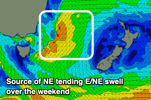
We’ve got a dynamic and great setup on the way for the East Coast for the period, with the stationary trough that’s currently sitting off the Mid North Coast of NSW due to slowly drift back south and strengthen, moving into our swell window.
We’re set to see strengthening E/NE-NE winds moving more into our swell window over the coming days as the trough shifts south through the Tasman Sea. Various embedded lows in the trough low should generate gale-force intensifications, with the end result being building levels of mid-period NE swell Friday ahead of some stronger energy through Saturday.
Tomorrow looks fun and slow to 2-3ft with building sets to 4ft are due Friday afternoon, if not a little bigger later with Saturday seeing stronger 6ft surf, if not a little stronger depending on the intensifications.
Winds look SW tending fresh N/NE on Friday as the swell eases, with Saturday offering improving surf under strengthening NW winds.
Strong NW tending N/NW winds will persist Sunday as the swell shifts more E/NE and eases, still 4-5ft+ thanks to the slow peeling away of the fetch east, towards New Zealand.
Moving into next week and the E/NE swell will continue to ease but another localised increase in N/NE windswell is likely as winds strengthen from the N’th ahead of a strong cold outbreak into Tuesday.
The models still diverge regarding the makeup of this outbreak but it looks like we’ll see some large, windy S’ly swell into Tuesday, fun into the middle to end of the week as winds weaken and swing more offshore. More on this Friday.