Fading north swell for the weekend

Eastern Tasmanian Forecast by Craig Brokensha (issued Friday April 25th)
Best Days: North magnets tomorrow morning, Wednesday and Thursday morning
Features of the Forecast (tl;dr)
- Fading NE swell tomorrow with W tending S/SE winds mid-late AM
- Tiny Sun/Mon
- Building S windswell Tue with strong S winds
- Moderate sized S/SE-SE swell Wed with strong SW tending S winds
- Better E/SE swell Thu with W tending NE winds
Recap
Yesterday started small and clean but winds quickly picked up out of the N/NE along with building levels of windswell.
Today conditions are much cleaner with fun 3ft sets easing out of the NE and the winds are still variable into this afternoon.
This weekend and next week (Apr 26 - May 2)
The weekend looks slow with the current NE energy due to continue to ease into the weekend, coming in at an inconsistent 2ft on the north magnets tomorrow.
Winds look offshore through the morning before a trough brings a S/SE tending E/SE-SE change mid-late morning.
Sunday will be even smaller and the trough will bring a tiny increase in SE windswell through Monday but to no major size.
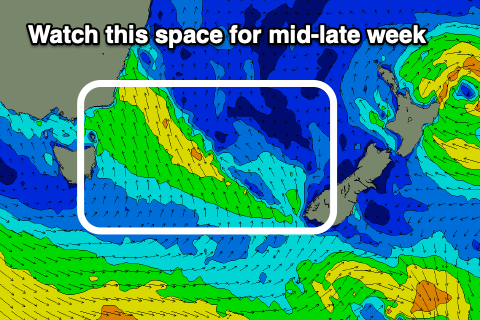
A more significant trough sliding up past the coast through Tuesday should bring strong S’ly winds and a building local S’ly windswell, with the trough possibly forming into a low into the middle of the week.
The low looks broad with the southern Tasman Sea expected to be filled with fetches of strong SE winds, generating building levels of mid-period E/SE swell for our region mid-late week.
At this stage with the fetch staying east of us we should see favourable local winds out of the south-western quadrant with the swell possibly coming in at 3ft+ Wednesday through Friday.
We’ll confirm this on Monday though. Have a great weekend!