Make the most of the current swell

Eastern Tasmanian forecast by Craig Brokensha (issued Friday April 18th)
Best Days: Today, tomorrow, Sunday morning
Features of the Forecast (tl;dr)
- Large E/NE swell easing steadily tomorrow, smaller Sun
- W tending E/NE winds Sat, N/NW tending fresh NE winds Sun
- Smaller Mon with strengthening S/SW tending S/SE winds
Recap
A fun close-range E’ly swell held the 3ft range through yesterday, while this morning we saw early surf in the same size range ahead of a strong kick in E/NE groundswell through the day. Exposed beaches are now 8-10ft with a strengthening N’ly wind, favouring selected spots.
This weekend and next week (Apr 19 - 25)
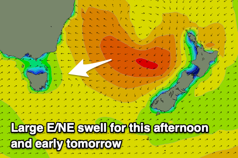
The large increase in E/NE groundswell seen this afternoon was generated by the extratropical transition of Tropical Cyclone Tam, with the swell due to peak overnight before easing off steadily through tomorrow.
The steady easing trend is thanks to a fetch of severe-gale E’ly winds projected through our swell window yesterday shifting more SE and away from us today, cutting off the main infeed towards us.
We should still see large sets to 8ft tomorrow morning across the magnets, easing back to 4-6ft through the day and then a smaller 4ft on Sunday morning.
Local winds tomorrow look great and offshore ahead of E/NE sea breezes, with N/NW tending fresh NE winds on Sunday.
Come Monday there isn’t expected to much east swell left in the tank and a trough will bring strengthening S/SE winds though swell wise no major energy is expected.
Later in the week a strengthening NE feed into an approaching trough may bring some localised N/NE windswell but the current energy is of much better quality so make the most of it! Have a great weekend!