Large north-east pulses to come this week

Eastern Tasmania Surf Forecast by Craig Brokensha (issued Monday October 2nd)
Best Days: Tomorrow morning and late, Thursday afternoon and early Friday, Saturday morning
Features of the Forecast (tl;dr)
- Mod-large N/NE swell building tomorrow with gusty NW tending strong N winds ahead of a late S/SE change in southern and central regions
- Smaller N/NE swell Wed with strengthening S/SE winds
- Building S windswell Thu with strong S/SW winds
- Mod-large NE groundswell building Thu, peaking later
- Fading NE groundswell Fri with a moderate sized + S windswell
- SW tending strong S/SW winds Fri
- Easing S windswell Sat with W/SW tending SE winds
Recap
Small levels of easing S swell on Saturday with a NE windswell through yesterday but on the build more noticeably this afternoon with strong N'ly winds.
This week and next (Oct 3 - 8)
We've got a very dynamic, tricky week of swell, wind and waves ahead thanks to deepening troughs drifting in from the west, squeezing against high pressure sitting towards New Zealand.
Currently we're seeing the first trough pushing in through the Bight, bringing a rapidly deepening and expanding fetch of strong to near gale-force N/NE winds that are extending from the southern NSW coast to our region.

This is kicking up a building N/NE windswell that looks to reach peak maturity tomorrow later morning.
North-east magnets should see building 4-6ft sets, smaller towards central and northern ends, and we'll see winds try and swing offshore, varying from the NW through the morning before going back strong N'th through the day ahead of a late S/SE change. This change looks to fall just short of Scamander before it goes dark so target further south.
A more pronounced and strengthening S/SE change is due on Wednesday but we'll fall between swells with 2ft to possibly 3ft leftovers in southern corners.
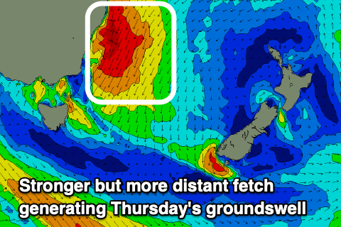
Our next pulse of NE groundswell is due on Thursday, building through the day and peaking into the afternoon, generated by another trough forming into a low off the southern NSW coast.
A more distant but stronger fetch of NE gales are forecast to be generated through our north-eastern swell window on Wednesday afternoon and evening, with the groundswell due to build back to 4-6ft across the magnets into the afternoon Thursday but with more power than tomorrow.
Strong S/SW winds should favour southern corners while also kicking up some local S'ly windswell but below the size of the NE energy.
Friday will then consistent of rapidly easing NE groundswell likely from 2-3ft max but some stronger S'ly windswell to 5-6ft or so. Winds will remain strong from the S/SW, veering SW through the early morning.
Come the weekend, easing levels of S'ly windswell with improving winds are due but we'll take a closer look at this Wednesday following the NE energy.