Tons of swell with fairly decent winds

Eastern Tasmanian Surf Forecast by Craig Brokensha (issued Monday December 5th)
Best Days: Southern corners tomorrow, Wednesday, Thursday morning, Saturday northern corners
Features of the Forecast (tl;dr)
- Mod-large SE swell tomorrow with strong S winds
- Mod-large SE-E/SE swell for Wed AM, easing steadily with W/SW-SW winds ahead of sea breezes (variable some locations)
- Small-mod sized S swell building Thu with strengthening W/SW-SW tending S/SW winds
- Easing S swell Fri with mod-fresh SW tending S/SE winds
- S/SE swell for Sat AM, then easing with W/NW tending NE winds
- Small N/NE windswell for later Sun, peaking Mon
Recap
There was nothing of note on the weekend with it consisting mostly of N/NE windswell with NE winds, but into yesterday afternoon, some stronger lines of NE groundswell appeared with workable onshore winds. The source of this swell was a strong low forming off the Queensland coast, expanding east across the northern Tasman Sea through Friday.
This low has continued to generate inconsistent sets from the NE today to 3ft but a deepening trough come low directly off our coast is now whipping up a rapid increase in S/SE swell energy. Protected spots are clean with strong S/SE winds.
This week and weekend (Dec 6 - 11)
The coming week will revolve around the low that's forming off our coast, with it being slow moving and fairly stationary through tomorrow before dipping south-east and being replaced by a secondary but less favourably aimed (for swell generation) low later week.
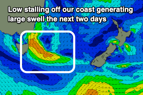
With the low sitting east of us this evening and tomorrow, we'll see a fetch of strong S/SE-SE winds being aimed through our south-eastern swell window.
This will produce a moderate-large SE swell for tomorrow, coming in at 5-6ft+ across the coast, biggest towards northern ends and smaller in southern corners along with strong S winds.
Wednesday looks great as the low dips south, swinging winds W/SW across most locations (more SW down EHN way) ahead of afternoon sea breezes. There'll be a bit more organisation to the swell as it eases and a more E/SE direction Wednesday morning, still 5-6ft but easing steadily during the day.
Thursday morning looks smaller and to 2-3ft along with strengthening W/SW-SW winds as the secondary system moves up the coast. This will see winds going S/SW into the afternoon along with a weak, small increase in S'ly swell to 3-4ft on the south magnets, easing from a similar size Friday.
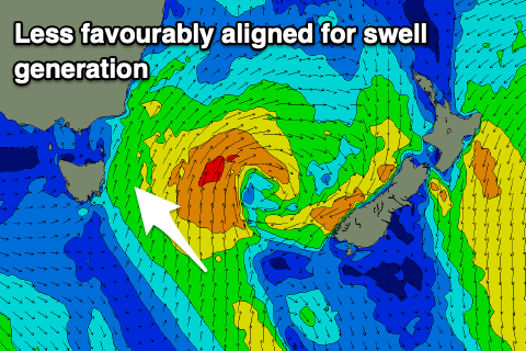
With the low positioned further east-northeast and away from us, size wise it will be nothing like the next couple of days.
Winds on Friday will be gusty from the SW, tending S/SE through the day.
On Saturday one final pulse of S/SE swell is due from the southern flank of the low, with sets to 2-3ft across northern corners under a better W/NW tending NE breeze.
Longer term we're looking at a N/NE windswell developing for Sunday afternoon and more so Monday but we'll look at this closer on Wednesday.