Building south energy later next week and weekend

Eastern Tasmanian Surf Forecast by Craig Brokensha (issued Friday June 3rd)
Best Days: Saturday morning for the keen, later next week and weekend
Features of the Forecast (tl;dr)
- Fading S/SE swell tomorrow with NW winds
- New small S swell Wed with W/SW-SW winds
- Moderate sized S swell for Thu/Fri with W/SW-SW winds
- Larger S swell next weekend with W/SW-SW winds
Recap
Great S/SE swell yesterday with offshore winds, still fun this morning but on the ease.
This weekend and next week (Jun 4 - 10)
Moving into the weekend, we'll see the current S/SE swell easing back from 1-2ft tomorrow morning but get in early before it flattens out.
Conditions will be offshore all day and come Sunday stronger N/NW winds are due but with only 1ft of N'ly windswell.
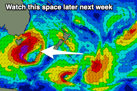 Looking at next week and there's nothing too major until mid-later next week when we see a strong node of the Long Wave Trough pushing slowly east across the southern Tasman Sea, further towards New Zealand.
This will see our southern swell window opening up to increasing polar frontal activity projecting favourably north past our coast.
Initial weak frontal activity on Tuesday through Thursday looks to generate weak S'ly swells to the 3ft range but come Friday and more so next weekend stronger and broader fetches of S/SW gales are due to be generated in our southern swell window. This will produce larger surf next weekend which at this stage should reach 6ft+ but we'll have another look at this Monday. Have a great weekend!