Flukey swell sources this period

Eastern Tasmanian Surf Forecast by Craig Brokensha (issued Monday April 25th)
Best Days: South magnets tomorrow morning, Thursday and Friday northern corners
Features of the Forecast (tl;dr)
- Small mid-period S swell tomorrow AM, easing with W/SW tending SE then NE winds
- Weak NE windswell building late Wed, peaking Thu with light N winds (possibly still lingering fresh NE), easing Fri with N winds
- Small NE windswell Sat with W/NW tending SW winds
- Inconsistent SE groundswell Thu, easing slowly Fri
Recap
Fun pulses of S’ly groundswell though strongest yesterday with favourable winds. Today the surf is on the ease but still decent across the south magnets.
This week and weekend (Apr 26 - May 1)
We’ll see the S’ly groundswell regime settling down over the coming days as the progression of strong polar fronts comes to an end. Tomorrow one final pulse of mid-period S’ly swell should maintain 2ft sets on the south magnets, fading through Wednesday. Winds aren’t ideal tomorrow but workable and light W/SW early, shifting SE and then NE into the afternoon.
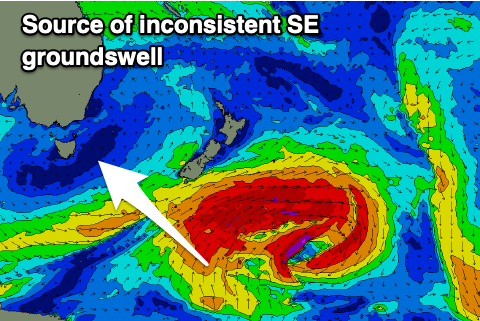 We then have some small, inconsistent SE groundswell due from a brief fetch of SE gales generated on the backside of a polar low forming south of New Zealand.
This should fill in Thursday with inconsistent 2ft sets due, easing from 2ft on Friday.
Also in the mix will be a building NE windswell through Wednesday/Thursday as a surface trough deepens and drifts down our east coast, bringing strong, local NE winds and a moderate sized NE windswell.
Building surf to 2-3ft is expected late Wednesday but with a gusty NE breeze, peaking Thursday morning to 3ft+ as winds ease and tend lighter N. ECMWF has the trough slower moving and this might keep NE winds blowing Thursday but keep the swell bigger into Friday. We'll reasses this Wednesday.
It won’t be especially strong but there should be some OK peaks for the keen. Easing surf is due Friday though lingering NE winds in our swell window should maintain 2ft of NE windswell both Friday and Saturday, cleanest on the former in southern corners as a SW change moves through Saturday afternoon.
Longer term there’s nothing too major on the cards besides some inconsistent E/NE trade-swell for mid-late next week. More on this Wednesday.