Good mix of easterly swells inbound

Eastern Tasmania Surf Forecast by Craig Brokensha (issued Monday February 7th)
Best Days: Later tomorrow keen surfers, Wednesday, Thursday, Friday morning, Monday southern corners once the change hits
Features of the Forecast (tl;dr)
- Building E/SE swell tomorrow with a stronger E'ly pulse later in the day, peaking Wed, easing Thu
- Mod-fresh SE-E/SE winds tomorrow, W/SW tending N/NE on Wed, then S/SW tending fresh SE on Thu
- Fading surf Fri with S/SW tending SE winds
- Building N/NE windswell Sun, easing Mon with N/NW tending S/SE winds
Recap
Easing levels of S-SE swell with clean conditions in the mornings, starting to increase again through today from the south-east
This week and weekend (Feb 8 - 13)
We’ve got some decent E/NE swell on the way for the coast as a strong high pressure ridge stretching from New Zealand up to the Queensland coast slowly tips more westward in orientation. This will see winds shift south-east to the east through our swell window, with an embedded low forming last night, projecting a better fetch of E/SE gales towards us today.
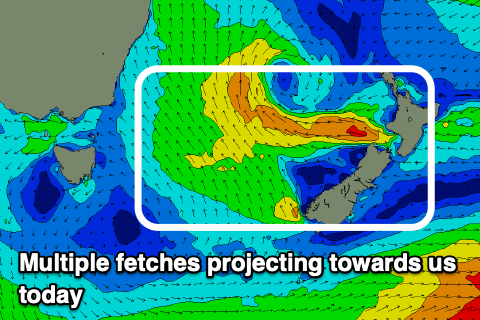 The low will continue moving towards us tomorrow, projecting a small burst of strong E/SE winds our way, with building levels of E/NE tending E swell due through tomorrow ahead of a peak Wednesday.
Size wise tomorrow morning looks to be around 3ft+, building to 4ft+ later in the day with Wednesday coming in at 4-5ft+ then dropping from the 4ft range Thursday morning.
Unfortunately winds look onshore tomorrow out of the SE-E/SE with Wednesday being the pick under W/SW tending NE winds. A trough looks to bring a S/SW change on Thursday with winds shifting S/SE into the afternoon.
Into the end of the week the surf will deteriorate with small facing levels of E’ly swell under S/SW tending SE winds, while some new NE windswell is on the cards Sunday afternoon, easing Monday but only to 2-3ft or so. More on this Wednesday.