Very active period ahead though windy

Eastern Tasmania Surf Forecast by Craig Brokensha (issued Monday 31st January)
Best Days: Protected spots Wednesday, Thursday and Friday morning
Features of the Forecast (tl;dr)
- Small N/NE and E/NE swells tomorrow with mod N tending stronger N/NW-NW winds
- Moderate sized, mid-period E/NE swell building Wed with gusty S/SW tending S/SE winds
- Easing E/NE swell Thu and Fri with fresh S/SW tending strong S/SE-SE winds
- Moderate sized S'ly swell for Wed and Thu, larger Fri
- Easing S swell Sat with S/SW tending fresh SE winds, smaller Sun with E/SE winds
Recap
Tiny levels of E/NE-NE windswell with favourable winds each morning.
This week and weekend (Feb 1 - 6)
We've got a very active period of surf ahead with a moderate sized mid-period E/NE swell followed by a prolonged S/SE swell episode.
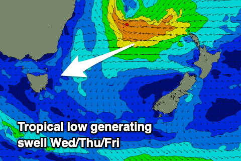 Firstly, the E/NE swell has and is still being generated by a healthy tropical low that developed in the Coral Sea, tracking south-southwest while expanding in scope on entering the Tasman Sea.
A great fetch of strong E/NE winds are being projected favourably towards us and this will be the most important part for swell production for our region.
The low is due to weaken this evening and tomorrow while tracking back to the south-southeast across New Zealand, leaving the swell to travel towards us, arriving through tomorrow evening and building through Wednesday ahead of a peak into the afternoon.
Ahead of the swell tomorrow, some weak N/NE windswell is due but only to 2ft or so (the models are over-forecasting the size and combining swells), with Wednesday building from 3ft to occasionally 4ft to 4-5ft through the afternoon.
Winds will swing from a moderate N'ly tomorrow morning to stronger N/NW-NW through the afternoon with a trough bringing a gusty S/SW tending S/SE breeze on Wednesday, favouring southern corners.
Thursday looks great with offshore winds and easing levels of E/NE swell from 3-5ft across open beaches, dropping from a smaller 3ft on Friday.
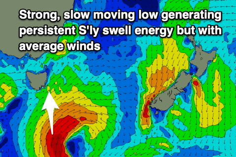 We then look at some moderate sized S'ly swell due from a low forming in the trough moving through Wednesday, with the low due to stall south-southeast of us through the middle to end of the week while generating a fetch of S/SW-S/SE gales.
This will produce some mid-period S'ly swell Wednesday to 3ft+ across south magnets, coming in at a similar size on Thursday ahead of the strongest pulse of swell Friday to 4-6ft on the south magnets.
Looking at the local winds and Thursday's early offshore will strengthen from the S/SW and tend S/SE into the afternoon, (not ideal) with similar S/SW tending SE winds on Friday.
Unfortunately winds won't really improve for south magnets into Saturday as the S/SE swell eases with a S/SW tending SE breeze, holding from the E/SE on Sunday as a high pressure system moves in from the west.
This looks to signal a new run of decent sized E/NE swell but we'll go into this in more detail next update.
Comments
are the models under-calling the wednesday/thursday swell?
Looks like it.